A 2001. év HUNAGI esemény-története -
- Registration of the Data Property of Public Administration in Hungary
In order to promote the access to public interest information managed by public administration and the better exploitation of the data property of public administration as a key resource, a government resolution has been signed by the Prime Minister in Hungary on the Registration of the data property of public administration. The resolution is dealing with the free access to the key characteristics of data sources and related concepts on a public network as well as of querying the access information of data sources. According to the resolution, a framework system for the registration of public administration data property was created by 31 January 2001.
After the initial loading of data (deadline: 30 June 2002), the continuous updating of the public administration data property register will be assured by the provision of the required resources, including regulatory, organisational, professional and other prerequisites of the commencement and maintenance of the service. By the way, the voluntary accession of all municipal and other public bodies to the public administration data property register will be facilitated. - The ABDS for the CEEC project, aiming at the preparation of an on-line service of administrative boundary data of the region has successfully accomplished its task – it is the main result of the EC review of the project held on 18 January 201 in Prague. As it was stated by the reviewers, Maciej Podemski (Poland) and Vincent Dessard (Belgium) the project achieved good results in tracing the structure of administrative hierarchy and of the change registry procedure in the countries of the CEEC region; elaborated and tested generalisation/simplification methods for compiling the ABDS products according to unique specifications; and built a competent network of specialists of mapping and statistical organisations. Moreover, the pilot project implemented in Hungary took the first steps towards an on-line real –time service. The results of the project and the expression of willingness for further collaboration were summarised in the Memorandum of Understanding, signed by representatives of Finland, Estonia, Latvia. Lithuania, Czech Republic, Romania, Bulgaria, Greece and Hungary. However the implementation of the service depend on many different factors. Besides of financing the most important thing is the interaction within the SABE and the future ABDS products. The teams of EuroGeographics and ABDS already has started about harmonisation of their activities. For more information please contact Ms.Katalin Tóth via abds@fomigate.fomi.hu
- The Hungarian Association for Geo-information was among the five European national GI associations (AFIGÉO, DDGI, AGI, RAVI and HUNAGI), which were interviewed on the spot and evaluated based on careful selected modelling by Mr.Koen van Biesen, expert of EUROGI in the last Quarter of 2000. The early results of the comparative study were discussed at the Executive Committee meeting of EUROGI in Apeldoorn on 19-20 January 2001. HUNAGI was found as a good example, how a GI association with a very limited budget can operate efficiently.
- In June 2001, the first EC Workshop on the use of cadastre will be hosted by the Hungarian GI Association (HUNAGI). The technical programme organised by the EC DG JRC SAI and the European Umbrella Organisation for Geographical Information (EUROGI) HUNAGI will be devoted to the issue, how cadastre as component of the national spatial data infrastructure can support the agri-environmental policies. The participants will have excellent opportunities to take part technical visits organised tentatively on sites related to different aspects of the Land Administration general and value-added service to support agri-environmental policy eg. land tenure tools for rural development in small regions, advanced education on land management, CAP institutional development (LPIS), Cadastre based Control with Remote Sensing etc. JRC has already organised the 4th EC Workshop on GI in conjuction with HUNAGI successfully three years ago. The tentative programme is in the Chapter devoted to Events in 2001.
- By the invitation of Under State Secretary Dr.Z.Kovács, a delegation Mr.Sönnichsen Dr. Elke Halm Rüdiger Evert lead by State Secretary Dr. Frank Tidick from Mecklenburg-Vorpommern has visited MARD on 25-26 January, 2001. The German experiences have been highlighted during the duscussions with 40 invited Hungarian experts with special emphasis on the village renewal, land consolidation and the management of land funds.
- 6th GSDI Conference – back to Europe – to Hungary. After Chapel Hill (North America), Sydney (Australia), Cape Town (Africa) and Cartagena (South America) Budapest will be the site of the 6th Global Spatial Data Infrastructure Conference.. This proposal was made by EUROGI based on evaluation of bids in competition environment and agreed by the GSDIl. The very first GSDI Conference was held in Europe, hosted by DDGI near to Bonn in Bad Königswinter in 1996. HUNAGI was represented at the meetings without interruption. The official press release is found in the Chapter devoted to the Events.
- Special Issue of the Journal “World of Nature” devoted to the Space including Earth observation and GIS
· A special issue will be published in the Spring 2001 orchestrated by the Hungarian Space Research Office containing a series of state-of-the-art comprehensive articles covering topics including economic benefits of the space activities in
· Agricultural yield estimation
· Environmental applicatons
· Use of EO in mapping and urban management
· Space activities and the GIS
· Satellites and weather forecast
· Thematic maps on energy balance
· Surface properties determination using satellites
· Use of meteorological image interpretation for short term forecasting
· Wider use of space-based telecommunication
· Satellite navigation tuday , tomorrow and later
· GPS applications in Hungary
· Space and life sciences
· Quality requirements in the space research
· Role of industry in the space activities
· Dosimetry - Pille (on the Space Station)
· Space and the impact on material sciences (UMC)
· Education and space policy
· Education, training and awareness raising in Hungary
· The institution of the Hungarian Space Research and its international links and future plans
· Highlights of the Space in the 21st Century
· Space literature in Hungarian language - Prepared by EU Phare expert dr.Richard A. Kidd a MARD-FÖMI delegation has visited DG JRC SAI MARS team in order to exchange view in topics such as CwRS, LPIS and AEMs.
- Between February 26-28, the countrywide visiting of the pilot sites of the computer (GIS) based land consolidation programme was performed by project manager Dr.Wolfram D.Kneib. Stopover of the round trip were in Bakonykúti, in Dabrony (Three Brooks Small Region), Gamás (Balaton Park 2000 Small Region), Kaposvár (Web-based GIS service provided by Kör Ltd) and Sásd (Hegyhát Rural Development Small Region). Country Co-ordinator of the TAMA project Dr.P.Riegler has arranded a farewell meeting for Dr.Kneib in Boly/Fenékpuszta, where the overall consequences and recommendadtions of the 7-years long project have been discussed with all of the leading experts of the participating County and District Land Offices.
- Preparation has been started for the participation of the UNECE WPLA Workshop on Land Administration and the EU accession will be held in Gavle, Sweden
- Financial documents related to the multiyear SAPARD framework have been signed by MARD State Secretary dr.Károly Tamás and dr.Jenő Varga, Minister of Finance with dr.Franz Fischler, Member of the European Commission, head of the DG Agri in Brussels, on 1st March, 2001.
- PRESS RELEASE January 25, 2001
Budapest to host sixth Global Spatial Data Infrastructure Conference
Seven years after the first of what has now become a regular series of Global Spatial Data Infrastructure Conferences was held in Bonn under the patronage of EU Commissioner Martin Bangemann this important event will return to Europe next year. At its meeting on January 24th 2001 the Steering Committee of the GSDI conference unanimously agreed to the proposal put forward by EUROGI President Ian Masser to hold the sixth GSDI conference in Budapest in September 2002. The conference will be organised the Steering Committee in conjunction with EUROGI and HunAGI the Hungarian national geographic information association.
The decision was the outcome of a competitive bidding process organised by EUROGI for its national member associations. HunAGI warmly welcomed the news that the GSDI will take place in Budapest. In the opinion of its Secretary, Dr. Gabor Remetey Fulopp, ' It is really a great pleasure and honour for HUNAGI and the whole Hungarian GI community. This challenge will have surely an anticipated spin-off effect providing positive impact on the acceleration of the spatial data infrastructure building related programs here.'
The EUROGI secretariat has already had preliminary discussions with EU officials regarding support from the Commission for this event. Now that the location of the Conference has been agreed the next round of discussions can get under way so that detailed proposals can be presented to the Steering Committee at the fifth GSDI conference in Cartagena, Colombia in May 2001.
EUROGI is the EURopean umbrella Organisation for Geographic Information. It has more than 20 national and pan European GI associations as members. In this capacity it represents over 3000 separate organisations in 20 different countries.
Its mission is to maximise the effective use of geographic information for the benefit of the citizen, good governance and commerce in Europe and to represent the views of the geographic information community in discussions with the European Union and other bodies.
GSDI is a global and open process for co-ordinating the organisation, management and use of geospatial data and related activities. It encompasses the policies, organisational remits, data, technologies, standards, delivery mechanisms, and financial and human resources necessary to ensure that those working at the global and regional scale are not impeded in meeting their objectives.
GSDI is being advanced through the leadership of many nations and organisations represented by a GSDI Steering Committee. This multi-national Steering Committee includes representatives from all continents, and all sectors - government, academia, and the private sector. The Steering Committee has identified a set of core goals to help advance awareness, acceptance and implementation of globally compatible spatial data infrastructures at the local, national, and regional levels:
· Articulate the operational environment needed to achieve Global SDI compatibility
· Help build globally compatible SDI capacity around the world
· Educate decision-makers on the benefits of GSDI inside and outside their borders
· Assure that different SDI related policies can be facilitated by the GSDI
· Advance the GSDI mission until a global SDI is achieved
Further information Contact Anton Wolfkamp or Karen Levoleger at the EUROGI secretariat. - On behalf of the Dutch Ministry of Economy Reviewer Drs Titia H.C.Slis of the Senter International and Jack Damen of DLG have discussed the land consolidation supported integrated rural development project proposal of the MARD. The project emphasise GIS based approach used by the 7-years long TAMA project experiences taking also into account the agri-environmental measures related requirements.
- The 2nd meeting of the Task Force related to the Sopron Conference was hosted by the Secretariat of the Hungarian Committee of the World Heritage on 13rd of March, under the co-chairmanship of Messrs. Ferenc Németh and Ambassador Janos Jelen. The conference scheduled for early September this year will focus on the potentialities of GIS techniques in the monitoring and documentation of the cultural landscapes and natural heritages. For more information please contact vilagorokseg@matavnet.hu. The annotation of the international conference under the sponsorship of ISPRS and EARSeL is described in the Chapter EVENTS.
- The venue of the meetings related to the GIS based documentation and monitoring of the World Heritage, the Ministry of Cultural Heritage in the Royal Castle District in Budapest
- Budapest welcomes the Global Spatial Data Infrastructure Conference in September 2002. For delivering the opening address by Mr. Liikanen, Member of the European Commission EUROGI and the host organisation Hungarian Association for Geo-Information has already started the preparations.
- Between March 6 and 14, CROPMON project team members Csaba Wirnhardt, Miklós Lelkes and others under leadership of Gabor Csornai of FÖMI RSC have provided near real time flood monitoring and area calculations based on digital satellite image processing for the regional and central flood combat headquarters. The operational GIS/RS based information dissemination is used the second consecutive years also for the MARD management.
- Arranged by the SPP twinning framework leader Ms.M.Digne, a full day working session was devoted to the concept and techniques of interministerial co-ordination based on the French experience. Mr.Damien Devouassoux, former prefect in DATAR, now General Secretary for Regional Affairs in Marseilles pointed out the role and importance of maps and geographical information. The experiences highlighted by Mr.Poinsssot, former member of the Prime Minister General Secretary for Interministerial Co-ordination, now at the Regional Council of the Midi-Pyrénées region could be also adapted by the process of decision making and building of consensus in any interdisciplinary situation as data policy and information access in GI environment.
- GIS OPEN 2001 Open Geo-informatics in the Millennium
Programme of the 1st day –Tuesday, 13 March
Topics of the Plenary Sessions:
Internet-based aerial photograph catalogue
On-line maps in Hungary
GIS – and its users
Digital Regia
County level GIS
Regional land use planning
Public information – path suggestion for the web
GIS-based decision support
Spatial data clearinghouse and the decision support
GIS for All
GIS-aided integration of databases
Internet –inter-spatial-data-network
Forum
Opening of the Exhibition
Reception
2nd day –Wednesday, 14 March
Topics of the Plenary Sessions:
The National Land Fund
EU Conference on “Use of cadastre” in Budapest
Experiences in digital mapping
TAKAROS and its ability to accept external map data
Results, experiences of the National Cadastral Programme
DITAB – the Digital Topographic Database standard
Marketing and the Land Offices
Service based on the products of the Aerial Survey 2000
Concept of the service of map-data in Europe
The 1:50 000 scale land cover mapping of Hungary
Forum, Closing - The land tenure policy also needs facilitating tools as National Land Fund and GIS based Land Consolidation technologies. Lecturer at the GIS Open: G.Apagyi special senior counsellor of DLM MARD
- Presentation on the GI-content of the FP6.
- After the Executive Committee Meeting held in Trier on 18th March, HUNAGI participated also the EUROGI Member’s Day, held in the Jean Monnet Building in Luxembourg-Kirchberg on 19th March. EU DG InfoSo representatives delivered presentations on the European Commission’s GI-related projects (COGI), as well as on the Framework Programmes. HUNAGI provided a short overview on the results of the Panel GI project.
- HUNAGI has participated the EUROGI Annual Board Meeting held on 20th March 2001, where also the EU Workshop on the Use of Cadastre to be held in Budapest between 7-9 June has been announced by Anton Wolfkamp, Secretary General of EUROGI.
- Ian Masser, Anton Wolfkamp, Pascal Jacques and Daniel Rizzi at the DG InfSo in the break of discussions of the GSDI6 to be held in Budapest in September 2002.
- A two days visit has been arranged by the PARCELLA LTTA
Dr..Richard A.Kidd, Detti Csonka staff member of FÖMI and DLM MARD for the experts of the European Commission DG Agri and DG JRC in CAP IACS issues. The venue of the first day was FÖMI RSC where the subject of the discussions was devoted to the technical details of Control with Remote Sensing as well as to the Land Parcel Identification System. The second day gave opportunity to exchange views, information with the decision makers of MARD and respective institutions. The new regulation prescribing the mandatory use of GIS after 2005 was also highlighted. - By the invitation of the Turkish Surveyors Organisations, FIG Commission 3 (Spatial Information Management) has delegated John Holmlund (Canada), Gerhard Muggenhuber (Austria) and G.Remetey-Fulopp (Hungary) to deliver lecture at the closing plenary session of the 8th Conference of the Turkish Surveyors. FIG delegation paid a visit at the Office of the Turkish Cadastral Service as well as at the Chamber of Surveyors too. The Hungarian participants was selected by the recommendation of the UN ECE WPLA. The Hungarian presentation illustrated the challenging tasks having institutional development character to be solved in a country of the region in transition in Central and Eastern Europe, a country, which has the aim to complete the adoptation of the “Acquis Communautaire” of the European Union in the next one and half years. General statistics, the role and activities of the Lands and Mapping organizations were provided, highlighting the widening spectrum of the applications using advanced technology as operational services provided by FOMI. Special emphasis was given to the capacity building and knowledge transfer programmes as OLLO, SDILA and LIME (orchestrated by Prof. Markus of WHU CSLM) and the value of cross-border as well as international networking (Panel GI and ABDS). As an example among FIG (explicitly mentioned the Land Market WG lead by A.Ossko, Hungary), UNECE WPLA, ECAI and EuroGeographics also EUROGI was introduced as an interdisciplinary Umbrella Organization for Geographical Information on European level, which is open for new members, such as national GI association.
- President Hüseyin Ülkü, Secretary General A.Fahri Özten and Chief of international relations Muhittin Ipek of the Chamber of Surveyors in Turkey at the banquet given for the FIG delegation. The Chamber could be a potential interdisciplinary GI Association in Turkey.
- The National Cadastre Programme Non-profit Co has been accepted as major contributor to HUNAGI with full membership right. The acceptance is based on the resolution of the General Assembly of December 14, 2000.
- April 7 HUNAGI completed the questionnaire of Uta Wehn de Montalvo of the Science and Technology Policy Research, University of Essex Survey on the Hungarian experience with the implementation of the national spatial data infrastructure. Ms.de Montalvo was satisfied with the Hungarian contribution and HUNAGI will receive a copy of the final report prepared to the GSDI5 in Cartagena.
- April 10. HUNAGI submitted the news on the political debate on the wider use of GI on the expert meeting arranged by the Chair MP Balsay of the Committee of the Regional Development of the Hungarian Parliament to EUROGI for Europe-wide dissemina-tion. The Parliamentary Committee on Regional Development chaired by Mr.István Balsay held a meeting dealing with GIS on April 12. Using EUROGI’s effective information dissemination channel the news was distributed throughout in Europe before the meeting. Information was provided based on HUNAGI’s invitation by dr. Szabolcs Mihály, director general of FÖMI, and feedback on the news was received on the same day already from France.
- April 10, JRC, EUROGI and HUNAGI finalised the Presentations of the EU Workshop on Cadastre to be held in Budapest between June 7-9, 2001.
- April 11 GIS-Day Coordinator Ms. Amy Thorson of ESRI found very exciting the topics of the planned professional content of the annual GIS –Day event scheduled for November 14, 2001. HUNAGI wrote:
Based on the definite success of the last year's event we have organised, the Theater Room having a capacity of 300 is reserved for November 14 in the historic building of the Ministry of Agriculture and Regional Development (just in opposite to the Parliament).
Last year we had the pleasure to have the dedicated videotaped message of Prof. Ian Masser, President of the European Umbrella Organisation for Geographical Information (EUROGI), as well as Dr.Jack Dangermond, "father" of this popular worldwide event.
The interdisciplinary national GI association HUNAGI arranges the event again in conjuction with its member Hungis Foundation. Major aim is to bring the age range 15-25 closer to the daily best practice where GIS is already used or could be used as a tool solving high priority problems achieving greater value for the society. Presenters as in the last years will be academicians, R+D, education and industry representatives, senior governmental decision makers as well as experts from NGOs.
This year the topics to be covered by the invited keynte speakers incudes e-content, how the public GI data can be made more accessible according to the e-Europe concept as well as how GI/GIS was already applied on national or supranational level related to global challenges as Agenda 21, Habitat +5 and Global Mapping.
This is timely, because Hungary will provide the venue of the 6th Conference on Global Spatial Data Infrastructure in Budapest September 2002 in a close co-operation of GSDI ExCom, EUROGI and HUNAGI. - The 10th Anniversary of HUNGIS Foundation for the Advance-ment in Geo-informatics was celebra-ted by a reception. Hosted by the Teacher’s Club of the Budapest University of Technology and Economics on April 11, 2001 and was participated about 40 senior managers of the private sector, governmental officers, scientists and university professors. The establishment of the HUNGIS Foundation was aiming to contribute to the development of Hungarian GIS. It was the original idea of János Szilágyi (V) innovative leader and owner of the Europe-wide known Geometria GIS System House Company 10 years ago. The vision was immediately supported by academician Ákos Detrekői who serves as Chairman of the Board of Curators for HUNGIS since that time. The daily operation is managed by Executive Director Dr.Rezső Berencei. HUNGIS Foundation was among the first 7 founders of HUNAGI, the Hungarian GIS Association working in conjuction with HUNGIS.
The event was attended also by the Governmental Commissioner for Informatics at the Prime Minister’s Office Mr.Zoltán Sík, who emphasized in his address the effective role of GIS as a tool in numerous governmental programme implementations. HUNAGI President Mr.Zsolt Sikolya congratulated to HUNGIS Officers Detrekői and Berencei on behalf of the HUNAGI members and submitted a CD-ROM illustrating the past 6 years of HUNAGI’s activities in close co-operation with HUNGIS. The present also contained the printed version of the Koen van Biesen Report of the European Umbrella Association for Geographic Information. - State Secretary Dr. János Tardy, Head of the Office of Nature Protection of the Ministry of Environment opened the inter-ministerial expert meeting devoted to the River Tisza’s oxbows on April 12. The presentation of Mr. Tamás Margescu was participated by the potential stakeholders, i.e. representatives of governmental agencies and relevant departments as well as NGOs and the directors of three National Parks (Hortobágy, Bükk and Kiskunság). Ms.Tehmina Akhtar, UNDP Advisor for biodiversity and international waters of Global Environmental Facility from Ankara, Mr.Rastislav Vrbensky specialist in sustainable development policy as well as Dr. István Tőkés Hungarian Liasion Officer were also present.
- A FIG report on the recent 8th Conference of the Turkish Surveyors dealing with GIS was submitted by SG of HUNAGI to Ms. Akhtar.
- Mr. László Haraszthy, Director of the World Wildlife Fund Hungary was invited by SG of HUNAGI to consider the co-operation with the national GI association and to become member. An up-to-date information material on CD-ROM was submitted to WWF in order beeing familiar with HUNAGI’s mission goal, its activities in the past 6 years and action plan for 2001.
- Debate on wider use of GIS within the Hungarian Parliamentary Commission for Regional Development
The information below is based on the ad-hoc summary written by Dr.Szabolcs Mihály participant at the experts' meeting of the Hungarian Parliamentary Committee for Regional Development, chaired by Mr.István Balsay MP on April 12, 2001. Quick release of this information was approved by Mr.Pál Vásárhelyi, Secretary of the Committee. Official Parliamentary version will be available in two weeks. - According to the agenda, the Governmental Commissioner for Flood Protection and follow-on Actions of the Ministry of Transportation and Water Management gave thorough information on the events related to the historical floods of the River Tisza in March 2001. He pointed out the need for mid- and long-term water management strategies and the application of Geographical Information System (GIS) to support their implementation. Even during the conceptual planning phase and approval procedure, the use of GIS is inevitable and detailed surveys are needed. As a map base, digital topographic products are available (also covering the Upper Tisza Region, where the situation was the worst). An aerial survey of Hungary was completed within 3 months in Spring 2000 covering practically all of the country at an image scale of 1:30000. Also special large scale aerial photographs were required in the disaster area. He underlined the importance of geographic information as a major component of the national data infrastructure, especially for the future. The use of digital orthophoto products was said to be applicable and beneficial, also in the relatively flat Great Plain region.
- The Organisation of Catastrophe Management has been introduced. ARC/Info based GIS system is used for disaster mitigation. The system is well established, has an administrative boundary database and smaller scale topographic maps are used. It is critical is to ensure that the partners provide user-data to each other when updating and operating.
- Data, products and monitoring service capabilities provided by FÖMI during the flooding in March 2001 was presented. Dr. Mihály introduced thematic image maps and statistics based on an analysis of multi-platform satellite data, using digital topographic maps as a background layer. Visual interpretation of colour aerial photographs and orthophoto products taken and produced before the highwater period was also used.
- Conclusions related to the use of Geographic Information and GIS in the flood mitigation were summarised as follow:
- There is a lack of quality and accurate digital elevation model (DEM) with regard to operational functionality. DEM complements maps and imageries and is inevitable for the determination of elevation at certain terrain points or locations as often needed in decision support.
- Set up an application for a seamless satellite imagery database applicable for image processing, analysis and computer aided visual interpretation . It is anticipated, the user requirements will generate raising task volumes at the FÖMI Remote Sensing Centre. - Recommendations by Mr. István Balsay, MP and Chairman of the Regional Development Committee of the Hungarian Parliament, included:
- The participating experts, national institutions and organisations such as Office of the Governmental Commissioner for Flood Protection, Catastrophe Management, Institute of Geodesy, Cartography and Remote Sensing, governmental stakeholders of the National Topographic Programme have a wide range of competency in this field.
- They should forward their proposals presented here to respective high-ranking politicians, e.g. their ministers, aiming at getting support for the use of GIS. This will not only support the case of natural disasters (damaging both human environment and economy) but also support using GIS on a constant basis. The aim is to gain support for the GI/GIS programme in a wider political circle. Experts recommend to solve flood-problems by more intensive use of GI infrastructure. The Regional Development Committee of the Hungarian Parliament will submit relevant initiatives in this context to the Governmental Commissioner for Informatics at the Prime Minister's Office. The next meeting will be held in the Upper-Tisza region, probably in May 2001. It is expected that the Regional Development Committee together with high-ranking politicians will pay a visit also at the FÖMI facilities in the next future.
It is supposed that in water management more concerted actions are necessary to support GI-related activities at the inter-ministerial level, especially in application topics such as river management and agricultural water management. - The Local Organising Committee of the EU Workshop on Cadastre was arranged by LOC Secretary G.Remetey at the Department of Lands and Mapping at the Ministry of Agriculture and Regional Development on 18th April, 2001. The meeting was attended by Deputy Heads of the relevant MARD Departments on Plant and Soil Protection as well as Lands and Mapping, Messr. I.Fésüs and G.Horváth respectively, Dr.M.Ágfalvy, General Director of CLSM UWH, Ms.E.Kovács of FOMI, Ms.B.Csonka of Phare PARCELLA project, Mr.G.Ponicsán, Executive Director of the National Cadastre Program Non-profit Co. as well as dr.Rezső Berencei, Executive Director of Hungis Foundation. The meeting had the subject, how to support the local arrangements. The up-to-date Tentative Programme of the Workshop was also promoted on HUNAGI News section of the website of Hungis Foundation (www.hungis.hu).
- Prof.Dr.Resmi Osmani, Director of the Directorate of Agriculture and Dr.Bardhyl Qilimi, Director of the Land Department of the Albanian Ministry of Agriculture & Food paid a visit at DLM MARD to discuss the Hungarian approach in Land Administration. Commissioned by Deputy Head Mr.G.Horváth, the guests were informed in details mentioning also the EU Workshop on “Use of Cadastre as component of the spatial data infrastructure in agricultural policy implementation”. The visitors were escorted by Ms.Viktória Vásáry of Szent István University. The action was driven by GTZ Germany, locally arranged by the Research Institute of Agricultural Economics and Informatics AKII.
- The Local Organising Committee of the EU Workshop on the use of Cadastre was arranged by LOC Secretary G.Remetey at the Department of Lands and Mapping at the Ministry of Agriculture and Regional Development on 3rd of May 2001. The meeting was attended by Dr.Géza Kőszegi, Head and Gábor Horváth, Deputy Head of the Department of Lands and Mapping, MARD. Messrsr. I.Fésüs Deputy of the Plant Health and Agri-Environmental Department, Dr.László Podmaniczky Vice-Director of the Environmental Management Institute of the Szent István University at Gödöllő were also present Ms. Erdélyi Erika of the Pest County Land Office,Dr.M.Ágfalvy, General Director of CLSM UWH. László Angyal of FOMI, Ms.B.Csonka of Phare PARCELLA project, Mr.G.Ponicsán, Executive Director of the National Cadastre Program Non-profit Co. as well as dr.Rezső Berencei, Executive Director of Hungis Foundation were also attended the preparatory meeting, concentrating on the logistics related to the poster exhibition and tehnical supports.
Jegyzőkönyv
amely készült 2001.év december 13. napján Budapesten, a MeH székház hivatalos helyiségében
(Budapest V. Kossuth tér 2-4 I.em 6)
Tárgy: a Magyar Térinformatikai Társaság (HUNAGI) 9. közgyűlése
Jelen vannak a Jelenléti íven szereplő tagszervezetek képviselői.
A közgyűlésen képviselt tagszervezetek a következők:
1. Debrecen Egyetem Agroinformatikai és Alkalmazott Matematika Tanszék (Prof.Dr.Herdon Miklós),
2. gita Magyarország (Dr.Csemnitczky László),
3. Geoinformatika Főiskolai Kar, Nyugat-Magyarországi Egyetem (Prof.dr.Márkus Béla meghatalmazottja),
4. Magyar Állami Földtani Intézet (Dr.Kardeván Péter),
5. Magyar Földrajzi Társaság (Prof.dr.Kertész Ádám),
6. Magyar Településfejlesztők és Felújítók Társasága (Dr.Vásárhelyi Miklós),
7. Magyar Földmérési, Térképészeti és Távérzékelési Társaság (Prof.Dr.Detrekői Ákos),
8. Magyar Űrkutatási Iroda, (dr.Both Előd meghatalmazottja),
9. HUNGIS Alapítvány (Dr.Berencei Rezső,)
10. Földmérési és Távérzékelési Intézet (FÖMI) (Dr.Mihály Szabolcs meghatalmazottja),
11. Neumann János Számítógéptudományi Társaság (Havass Miklós),
12. MH Térképészeti Szolgálat (Kádár István),
13. MEH Informatikai Kormánybiztosi Iroda (Sikolya Zsolt),
14. Magyar Agrárinformatikai Szövetség (Prof.Dr.Harnos Zsolt meghatalmazottja),
15. VÁTI Kht (Barkóczi Zsolt),
16. Szent István Egyetem Környezet- és Tájgazdálkodási Intézet (Dr.Podmaniczky László meghatalmazottja),
17. MTA TAKI GIS Labor (Dr.Pásztor László),
A tagfelvételre jelentkezettek közül:
18. Balaton Park 2000 (Jeszenszky János meghatalmazottja)
19. Bloominfo konzorcium (Podolcsák Ádám)
20. Bonaventura Bt. (Dr.Szabó Szilárd)
21. Debrecen Egyetem Víz- és Környezetgazdálkodási Tanszék
22. ELTE Térképtudományi Tanszék (Dr.Jesús Reyes)
23. HISZI-Map (Göndöcs Péter)
24. HM Térképészeti Kht. (Buga László)
25. Kaposvári Egyetem Matematikai és Informatikai Tanszék (Dr.Bánkuti Gyöngyi)
26. Kaposvár-Somogyjád Kistérségi Vidékfejlesztési Kht.
27. Magyar Földmérő és Térképész Vállalkozók Egyesülete (Dr.Gross Miklós)
28. Nemzeti Kataszteri Program Kht. (Dr.Váczy Attila)
29. Nyugat-Magyarországi Egyetem Erdőmérnöki Kar Földmérési és távérzékelési Tanszék (Prof.Dr.Bácsatyai László)
30. Országos Meteorológiai Szolgálat (Szalai Sándor)
31. Webhu Kft (Csizmazia Tibor)
32. WWF Magyarország (Bozsó Brigitta)
Dr.Remetey-Fülöpp Gábor főtitkár
Kimentéssel, késve, csak a 2.napirendi pont szavazása után érkezett: Detrekői Ákos akadémikus és Havass Miklós (mindketten előzőleg írásos felhatalmazást adtak a főtitkár részére távollétük idején nevükben az elfogadó szavazásra), Késve érkezett (kimentéssel) Dr.Kőszegi Géza az FVM FTF főosztályvezetője, állandó meghívott.
Kimentéssel távol vannak:
33. Szent István Egyetem Tájtervezési és Területfejlesztési Tanszék (Dr.Kollányi László),
34. Pázmány Péter Tudományegyetem Bölcsészettudományi Kar (Rudán Pál)
35. Budapesti Műszaki Egyetem Fotogrammetria és Térinformatikai Tanszék (Dr. Mélykúti Gábor)
36. Bekes Kft (Kákonyi Gábor)
37. Gábor Dénes Alapítvány (Prof.Dr.Sélinger Sándor)
Jelen János nagykövet (állandó meghívott)
Kurátor Kft. (Simon Judit) meghívott
Távol vannak továbbá:
38. Állami Erdészeti Szolgálat (Mezei László)
39. DigiTerra Geoinformatikai Rendszerház (Nyull Balázs)
40. GeoX Kft.(Prajczer Tamás)
41. Fővárosi Növényegészségügyi és Talajvédelmi Állomás (Dr.Szalai László)
42. VITUKI Consult Rt (Galambos István meghatalmazottja),
43. GRID Budapest (Bozó Pál),
44. HUNGARNET Egyesület (Nagy Miklós),
45. JATE Természetföldrajzi Tanszék (Prof.Dr.Mezősi Gábor),
46. Magyar Közigazgatási Informatikai Egyesület (Bodnár János),
Bognár Vilmos OM K+F Helyettes Államtitkárság (állandó meghívott)
Sikolya Zsolt levezető elnök üdvözli a megjelenteket.
1. napirend
Az elnök bejelenti, az előző közgyűlések határozatával megerősített tagok száma: 26. A közgyűlésen a tagok illetve képviselőik legalább 50%-a +1 kell jelen legyen. Ez 14 tagszervezetet jelent. Mivel az előző közgyűlések határozatával megerősített tagok közül 17-en vannak jelen, az elnök megállapítja a Közgyűlés szavazatképességét.
Az elnök ismerteti a Meghívóban szereplő közgyűlési napirendi javaslatot, a 8.pont részletezésével:
1. A napirend elfogadása, határozatképesség megállapítása, jegyzőkönyv-vezető és a hitelesítők megválasztása
2. Az új tagok bemutatása és közgyűlési határozathozatal
3. Főtitkári beszámoló a 2001. évi tevékenységről hozzászólások és közgyűlési határozathozatal
4. Pénzügyi beszámoló a 2001. évről (dr. Berencei Rezső), hozzászólások és közgyűlési határozathozatal
5. A 2002. év tervezett feladatai (dr. Remetey-Fülöpp Gábor) és a 2002.év költségvetés-tervezete (dr. Berencei Rezső)
hozzászólások és közgyűlési határozathozatal
6. A főtitkári tisztség betöltésére vonatkozó javaslat, hozzászólások és közgyűlési határozathozatal (felvezető: Sikolya Zsolt)
7. Az elnöki tisztség betöltésére vonatkozó javaslat, hozzászólások és közgyűlési határozathozatal (felvezető: Prof.Dr.Detrekői Ákos)
8. Alapszabály módosításra vonatkozó javaslat megvitatása (felvezető: dr. Remetey-Fülöpp Gábor, indoklás: dr.Berencei Rezső), majd az ebből következő határozathozatalok:
8.1 A közgyűlés a Társaság Alapszabályát a közhasznú szervezetekről szóló 1997.évi CLVI.törvény szerint módosította, illetve annak követelményeivel kiegészítette. A közgyűlés a módosított alapszabályról szavaz.
8.2 A tiszteletbeli elnöki tisztség betöltésére vonatkozó javaslat, hozzászólások és közgyűlési határozathozatal (felvezető: Prof.Dr.Detrekői Ákos)
8.5 A pénztáros betöltésére vonatkozó javaslat, hozzászólások és közgyűlési határozathozatal (felvezető: Sikolya Zsolt)
8.6 Az Ellenőrző Bizottság betöltésére vonatkozó javaslat, hozzászólások és közgyűlési határozathozatal (felvezető: Sikolya Zsolt)
8.7 A Társaság tagdíjainak megállapítása: hozzászólások és határozathozatal
9. Egyebek
A Közgyűlés 43. (2001.12.13) számú határozatával a napirendi javaslatot egyhangúlag elfogadja.
Az elnök a jegyzőköny vezetésére dr. Berencei Rezső, a jegyzőkönyv hitelesítésére Kádár István és Barkóczi Zsolt személyére tesz javaslatot.
A Közgyűlés 44. (2001.12.13) számú határozatával a javaslatot 16 szavazattal, 1 tartózkodással elfogadja.
2. napirend
Az elnök felkéri a tárgyévre tagfelvételi kérelmeket benyújtott szervezetek képviselőit, 1 percben mutassák be intézményüket és egyenkénti szavazással kéri a Közgyülést határozatilag erősítse meg a tagfelvételt.
|
Dr.Váczy Attila képviselő bemutatja a szervezetet |
|
Nemzeti Kataszteri Program Kht |
|
A felvételi kérelmet a Közgyűlés 45. (2001.12.13) számú határozatával egyhangúlag elfogadja |
||
|
Buga László igazgató bemutatja a szervezetet |
|
HM Térképészeti Kht. |
|
A felvételi kérelmet a Közgyűlés 46. (2001.12.13) számú határozatával egyhangúlag elfogadja |
||
|
Jáger János elnök bemutatja a szervezetet |
|
Kaposvár-Somogyjád Kistérségi Vidékfejesztési Kht |
|
A felvételi kérelmet a Közgyűlés 47. (2001.12.13) számú határozatával egyhangúlag elfogadja |
||
|
Jeszenszky János Elnök Helyett Jáger János bemutatja a szervezetet |
|
Balaton Park 2000 Környezetvédelmi Kht., |
|
A felvételi kérelmet a Közgyűlés 48. (2001.12.13) számú határozatával egyhangúlag elfogadja |
||
|
Rudán Pál helyett a főtitkár bemutatja a szervezetet |
Képviselő |
Pázmány Péter Katolikus Egyetem Bölcsésztudományi Kar |
|
A felvételi kérelmet a Közgyűlés 49. (2001.12.13) számú határozatával 16 szavazattal, 1 tartózkodással, elfogadja |
||
|
Dr.Bácsatyai László bemutatja a szervezetet |
|
Nyugatmagyarországi Egyetem Erdészeti Kar Földmérési és Távérzékelési Tanszék Sopron |
|
A felvételi kérelmet a Közgyűlés 50. (2001.12.13) számú határozatával egyhangúlag elfogadja |
||
|
Csizmazia Tibor Képviselő bemutatja a szervezetet |
|
WEBhu Kft. |
|
A felvételi kérelmet a Közgyűlés 51. (2001.12.13) számú határozatával egyhangúlag elfogadja |
||
|
Bozsó Brigitta bemutatja a szervezetet |
Képviselő |
WWF Magyarország, |
|
A felvételi kérelmet a Közgyűlés 52. (2001.12.13) számú határozatával egyhangúlag elfogadja |
||
|
Kákonyi Gábor helyett a főtitkár bemutatja a szervezetet |
ügyv.igazgató |
Bekes Kft. |
|
A felvételi kérelmet a Közgyűlés 53. (2001.12.13) számú határozatával egyhangúlag elfogadja |
||
|
Prajczer Tamás helyett az elnök bemutatja a szervezetet |
ügyvezető ig. |
GeoX Kft , |
|
A felvételi kérelmet a Közgyűlés 54. (2001.12.13) számú határozatával egyhangúlag elfogadja |
||
|
Dr. Bánkuti Gyöngyi bemutatja a szervezetet |
tansz.vez.egy.docens |
Kaposvár Egyetem Matematikai és Informatikai Intézet |
|
A felvételi kérelmet a Közgyűlés 55. (2001.12.13) számú határozatával egyhangúlag elfogadja |
||
|
Dr.Tamás János bemutatja a szervezetet |
Tanszékvez.egy.docens |
Debrecen Egyetem Víz- és Környezetgazdálkodási Tanszék |
|
A felvételi kérelmet a Közgyűlés 56. (2001.12.13) számú határozatával egyhangúlag elfogadja |
||
|
Podolcsák Ádám Képviselő bemutatja a szervezetet |
|
Bloominfo Kft. |
|
A felvételi kérelmet a Közgyűlés 57. (2001.12.13) számú határozatával 16 szavazattal, 1 tartózkodással, elfogadja |
||
Nyull Balázs helyett a főtitkár bemutatja a szervezetet |
|
DigiTerra GEOinformatikai Rendszerház Kft 1123Budapest, Táltos u. 15/a info@digiterra.hu |
|
A felvételi kérelmet a Közgyűlés 58. (2001.12.13) számú határozatával egyhangúlag elfogadja |
||
|
Jesús Reyes képviselő bemutatja a szervezetet |
|
ELTE Térképtudományi Tanszék 1117 Budapest, Pázmány Péter sétány 1/A Tel: 2090555/6723, 3722975, fax: 3722951 - http://lazarus.elte.hu |
|
A felvételi kérelmet a Közgyűlés 59. (2001.12.13) számú határozatával egyhangúlag elfogadja |
||
|
Dr.Gross Miklós Elnök bemutatja a szervezetet |
|
Magyar Földmérő és Térképész Vállalkozások Egyesülete BudapestGross.miklos@axelero.hu |
|
A felvételi kérelmet a Közgyűlés 60. (2001.12.13) számú határozatával egyhangúlag elfogadja |
||
Mezei László helyett a főtitkár bemutatja a szervezetet |
Osztályvezető
|
Állami Erdészeti Szolgálat BudapestPf.10, 1355 |
|
A felvételi kérelmet a Közgyűlés 61. (2001.12.13) számú határozatával egyhangúlag elfogadja |
||
|
Göndöcs Péter ügyvezető igazgató bemutatja a szervezetet |
|
HISZI-MAP |
|
A felvételi kérelmet a Közgyűlés 62. (2001.12.13) számú határozatával egyhangúlag elfogadja |
||
Dr.Szabó Szilárd Főszerkesztő bemutatja a szervezetet
|
|
Bonaventura térinformatikai piacelemző és publikációs Bt BudapestTáltos u. 10 terinformatika@axelero.hu |
|
A felvételi kérelmet a Közgyűlés 63. (2001.12.13) számú határozatával egyhangúlag elfogadja |
||
|
|
|
Országos Meteorológiai Szolgálat BudapestKitaibel Pál út 1. s.szalai@omsz.hu |
|
A felvételi kérelmet a Közgyűlés 64. (2001.12.13) számú határozatával egyhangúlag elfogadja |
||
|
|
|
Világörökségi ProgramirodaNemzeti Kulturális Örökség MinisztériumaBudapestVilagorokseg@axelero.hu |
Kérdésre a főtitkár bejelenti, a Világörökségi Programiroda vezetője Németh Ferenc úr a kérelem beadása előtt közúti balesetet szenvedett és életét vesztette |
||
Az elnök bejelenti, hogy a közgyűlési határozatokkal megerősítve a tagok száma: 46-ra emelkedett, ezért ismételten meg kell állapítani a Közgyűlés szavazatképességét. A közgyűlésen a tagok illetve képviselőik legalább 50%-a +1 kell jelen legyen. Ez 24 tagszervezetet jelent. Mivel a tagok közül 32-en vannak jelen, az elnök megállapítja, hogy a Közgyűlés szavazatképes maradt.
3. napirend
A 2001.évi tevékenységről szóló, mintegy 10 percben összefoglalt, előzőleg írásban is kiadott főtitkári beszámoló kapcsán hozzászólásként elhangzott az egyébként értékesnek és hasznosnak tartott hírközvetítések jobbítására vonatkozó javaslat.
Dr.Pásztor László és Csizmazia Tibor felajánlották közreműködésüket egy felállítandó, a HUNAGI hírforgalom optimalizálását célul kitűző feladatcsoportban.
A HUNAGI 2001.évi tevékenységéről szóló jelentést a Közgyűlés 65. (2001.12.13) számú határozatával vita nélkül egyhangúlag elfogadja.
A Közgyűlés 66. (2001.12.13) számú határozatával a főtitkár kezdeményezésére jegyzőkönyvi dícséretben részesíti 2001.évben évben végzett munkájukért dr.Berencei Rezső, Angyal László és Király Tibor kollegákat és felhatalmazta az elnököt, hogy saját hatáskörben intézkedjen nevezettek lehetőség szerinti megjutalmazásáról.
4. napirend
A 2001.évre szóló, dr.Berencei Rezső által írásban is kiadott pénzügyi jelentést a Közgyűlés vita nélkül 67.(2001.12.13) számú határozatával egyhangúlag elfogadja.
5.napirend
Beszámoló a HUNAGI 2002.évi tervezett feladatairól. Az írásban kiadott munkatervet a főtitkár mintegy 10 perces szóbeli kiegészítéssel terjeszti a közgyűlés elé. A Webhu a HUNAGI tervezett www.hunagi.hu kezdőlapjának kialakításában (amely nem helyettesíti, csak kiegészítené az eddigi www.fomi.hu/hunagi hálóhelyet), felajánlotta segítségét.
Az előterjesztést a Közgyűlés 68. (2001.12.13) számú határozatával egyhangúlag elfogadja.
Ezt követően dr.Berencei Rezső ad ismertetést a 2002.évi pénzügyi terv keretszámait, felhívva a figyelmet a jövőbeni önálló pénzügyi gazdálkodással és a közhasznúsággal együttjáró adminisztrációs többletköltségekre. Az EUROGI vezetőségi tagsággal járó tervezett utazási keret csökkenthető a 2001.évihez képest azáltal, hogy a GSDI konferencia jövőre Budapesten kerül megrendezésre (ami egyben lényeges bevételt is jelenthet). Az elhangzott hozzászólások alapján az elnök javasolja a Közgyűlés számára a pénzügyi terv elfogadását.
A 2002.évi pénzügyi tervet a Közgyűlés 69. (2001.12.13) számú határozatával egyhangúlag elfogadja.
6.napirend
A főtitkár távollétében, Sikoly Zsolt elnök javaslatot tesz a főtitkári tisztség alapszabály szerinti újabb három éves időtartamra való betöltésére dr.Remetey-Fülöpp Gábor személyében.
A Közgyűlés 70.(2001.12.13) számú határozatával az előterjesztést egyhangúlag elfogadja.
7.napirend
Sikoly Zsolt elnök a 7.napirend megtárgyalása idejére átadja a levezető elnökséget Dr.Detrekői Ákosnak majd elhagyja a termet. Távollétében a levezető elnök érdemeit méltatva javaslatot tesz az elnöki tisztség alapszabály szerinti újabb két éves időtartamra való betöltésére Sikolya Zsolt személyében.
A Közgyűlés 71.(2001.12.13) számú határozatával az előterjesztést egyhangúlag elfogadja.
.
8.napirend
A főtitkár ismerteti a közhasznú szervezetekről szóló 1997.évi CLVI.törvény szerint módosított, illetve annak követelményeivel kiegészített Alapszabály tervezetét, melyet megbízás alapján a Kurátor Kft. Titkárságvezetője, Simon Judit készített el, és amelyet a Közgyűlés időpontja előtt a tagság tanulmányozás céljából megkapott.
8.1
A módosított Alapszabályt - azon a kiegészítés-javaslatokkal, hogy az elnököt két alkalommal lehessen 2 évre újra választani, és a négy fős elnökség a tiszteletbeli elnököt és a pénztárnokot is foglalja magában - a Közgyűlés vita nélkül - az 72. (2001.12.13) számú határozatával egyhangúlag elfogadta, és ebből következően a további határozatokat hozta:
8.2
Detrekői Ákos akadémikus előterjesztése az elnökségben a tiszteletbeli elnöki tisztség betöltésére - időbeli korlátozás nélkül - Havass Miklóst a Társaság 1994-1999 közötti időszakban választott elnökét javasolja.
A Közgyűlés 73. (2001.12.13) számú határozatával az előterjesztést egyhangúlag elfogadja.
8.3
Sikolya Zsolt elnök előterjesztésére az elnökségben a pénztáros betöltésére dr.Berencei Rezsőt javasolja, aki megalakulása óta kezelte a HUNAGI pénzügyeit a HUNGIS Alapítványnál.
A Közgyűlés 74. (2001.12.13) számú határozatával az előterjesztést egyhangúlag elfogadja.
8.4
Az Ellenőrző Bizottság betöltésére vonatkozó javaslattételre nem került sor, mert a pénztáros indoklása szerint a Társaság 2002.évi tervezett bevételei nem haladják meg azt a küszöböt, mely felett ilyen testület létrehozása előírás.
Az indoklást a Közgyűlés - az 75. (2001.12.13) számú határozatával egyhangúlag elfogadja.
8.7 A Társaság tagdíjainak megállapítása
A tagdíjpolitikában nem volt szükséges változást eszközölni.
Tagdíj illetve információszolgáltatási díjkategóriák:
Költségvetési és akadémiai intézmények, nem-kormányzati szervezetek és egyesületek: 14 000 Ft/év
Bevétellel is rendelkező költségvetési szervezetek: 35 000 Ft/év
Vállalkozói, pártoló/hozzájárulási támogatást biztosító tagság: min. 50 000 Ft/év
Térségi képviseletek (kistérség, régió): 100 000 Ft/év
Az előterjesztést a Közgyűlés az elnök javaslatára - az 76. (2001.12.13) számú határozatával egyhangúlag elfogadja.
Az elnök bejelenti, hogy a Magyar Térinformatikai Társaság az elfogadott alapszabályt egységes szerkezetbe foglalva benyújtja a Fővárosi Bíróságra, közhasznú nyilvántartásba vétel végett. Az ehhez a lépéshez szükséges kisérő-dokumentumok elkészítésére, a megfelelő űrlapok aláírására a tisztségviselőket felkéri. A Társaság titkos szavazással megválasztott tisztségviselői (tiszteletbeli elnök, elnök, főtitkár és pénztáros) tisztségüket elfogadták.
A Közgyűlés 77. (2001.12.13) számú határozatával a bejelentést egyhangúlag elfogadja.
9.
Az egyebekben a következő tájékoztatások hangzottak el:
Dr.Herdon Miklós bejelentette a Debreceni Egyetem és az általa képviselt tanszék új adatait.
Dr.Kardeván Péter bejelentette, a GEMS EU DG JRC programjához való csatlakozás koordinációja keretében a HUNAGI főtitkárán keresztül információs anyagot bocsát a tagszervezetek rendelkezésére.
Dr.Bánkuti Gyöngyi bejelentette, a Kaposvári Térinformatikai Konferencia nem ősszel, hanem tavasszal kerül megrendezésre.
További hozzászólás híján Sikolya Zsolt elnök a Közgyűlést bezárja.
Megjegyzés: a Közgyűlés résztvevői kézhez kapták
1. Beszámoló a 2001. évi tevékenységről ( 3.napirendhez)
2. Pénzügyi beszámoló az elmúlt egy éves időszakról (4.napirendhez)
3. A 2002. év tervezett feladatai (5.napirendhez)
4. A HUNAGI -t röviden bemutató anyag a tagszervezetek adataival (ellenőrzésre)
5. Módosított Alapszabály tervezet
-
A Közgyűlés egyéb dokumentumai (meghívó a napirenddel, jelenléti ív) a HUNAGI Titkárságán betekintésre hozzáférhető.
Kmf.
Sikolya Zsolt
A Társaság elnöke
Dr.Berencei Rezső
jegyzőkönyvvezető
Hitelesítők: ………………….. ……………….
Kádár István Barkóczi Zsolt
ACTIVITIES IN 2001 (FIRST HALF)
Registration of the Data Property of Public Administration in Hungary
In order to promote the access to public interest information managed by public administration and the better exploitation of the data property of public administration as a key resource, a government resolution has been signed by the Prime Minister in Hungary on the Registration of the data property of public administration. The resolution is dealing with the free access to the key characteristics of data sources and related concepts on a public network as well as of querying the access information of data sources. According to the resolution, a framework system for the registration of public administration data property was created by 31 January 2001.
After the initial loading of data (deadline: 30 June 2002), the continuous updating of the public administration data property register will be assured by the provision of the required resources, including regulatory, organisational, professional and other prerequisites of the commencement and maintenance of the service. By the way, the voluntary accession of all municipal and other public bodies to the public administration data property register will be facilitated.

Tamás Palya with visitors at the booth of the Hungarian Exhibitors hotsing the PANEL GI project poster in Nice at the IST Conference

Participants of the Closing Workshop of the ABDS Project hosted by the Czech partner institution in January 2001..(Image courtesy by K.Tóth of FÖMI.)
· The ABDS for the CEEC project, aiming at the preparation of an on-line service of administrative boundary data of the region has successfully accomplished its task – it is the main result of the EC review of the project held on 18 January 201 in Prague. As it was stated by the reviewers, Maciej Podemski (Poland) and Vincent Dessard (Belgium) the project achieved good results in tracing the structure of administrative hierarchy and of the change registry procedure in the countries of the CEEC region; elaborated and tested generalisation/simplification methods for compiling the ABDS products according to unique specifications; and built a competent network of specialists of mapping and statistical organisations. Moreover, the pilot project implemented in Hungary took the first steps towards an on-line real –time service. The results of the project and the expression of willingness for further collaboration were summarised in the Memorandum of Understanding, signed by representatives of Finland, Estonia, Latvia. Lithuania, Czech Republic, Romania, Bulgaria, Greece and Hungary. However the implementation of the service depend on many different factors. Besides of financing the most important thing is the interaction within the SABE and the future ABDS products. The teams of EuroGeographics and ABDS already has started about harmonisation of their activities. For more information please contact Ms.Katalin Tóth via abds@fomigate.fomi.hu
· The Hungarian Association for Geo-information was among the five European national GI associations (AFIGÉO, DDGI, AGI, RAVI and HUNAGI), which were interviewed on the spot and evaluated based on careful selected modelling by Mr.Koen van Biesen, expert of EUROGI in the last Quarter of 2000. The early results of the comparative study were discussed at the Executive Committee meeting of EUROGI in Apeldoorn on 19-20 January 2001. HUNAGI was found as a good example, how a GI association with a very limited budget can operate efficiently.

A comprehensive analysis of the models for national GI associations in Europe presented by Koen van Biesen at the ExCom meetiong of EUROGI. (Photo courtesy by G.Remetey of HUNAGI)

EUROGI Executive Committee Meeting at work (January)
EU Cadastre Workshop in Budapest
In June 2001, the first EC Workshop on the use of cadastre will be hosted by the Hungarian GI Association (HUNAGI). The technical programme organised by the EC DG JRC SAI and the European Umbrella Organisation for Geographical Information (EUROGI) HUNAGI will be devoted to the issue, how cadastre as component of the national spatial data infrastructure can support the agri-environmental policies.
The participants will have excellent opportunities to take part technical visits organised tentatively on sites related to different aspects of the Land Administration general and value-added service to support agri-environmental policy eg. land tenure tools for rural development in small regions, advanced education on land management, CAP institutional development (LPIS), Cadastre based Control with Remote Sensing etc. JRC has already organised the 4th EC Workshop on GI in conjuction with HUNAGI successfully three years ago. The tentative programme is in the Chapter devoted to Events in 2001.

Meeting held at the Fejér County Land Office in Székesfehérvár
By the invitation of Under State Secretary Dr.Z.Kovács, a delegation Mr.Sönnichsen Dr. Elke Halm Rüdiger Evert lead by State Secretary Dr. Frank Tidick from Mecklenburg-Vorpommern has visited MARD on 25-26 January, 2001. The German experiences have been highlighted during the duscussions with 40 invited Hungarian experts with special emphasis on the village renewal, land consolidation and the management of land funds.
The model village Majs was selected to illustrate the impact of the Land Compensation and privatisation of the co-operatives. FÖMI RSC has also produced the CD extract of the 1:30 000 scale aerial photograph of the settlements vicinity from the nationwide aerial survey executed in Spring 2000, the time of the Complete Agricultural Census.


The secretariat’s infrastructure was provided by the Dept. of Lands and Mapping, Ministry of Agriculture and Regional Development since 1994
6th GSDI Conference – back to Europe – to Hungary
· After Chapel Hill (North America), Sydney (Australia), Cape Town (Africa) and Cartagena (South America) Budapest will be the site of the 6th Global Spatial Data Infrastructure Conference.. This proposal was made by EUROGI based on evaluation of bids in competition environment and agreed by the GSDIl. The very first GSDI Conference was held in Europe, hosted by DDGI near to Bonn in Bad Königswinter in 1996. HUNAGI was represented at the meetings without interruption. The official press release is found in the Chapter devoted to the Events.
Special Issue of the Journal “World of Nature” devoted to the Space including Earth observation and GIS
· A special issue will be published in the Spring 2001 orchestrated by the Hungarian Space Research Office containing a series of state-of-the-art comprehensive articles covering topics including economic benefits of the space activities in
· Agricultural yield estimation
· Environmental applicatons
· Use of EO in mapping and urban management
· Space activities and the GIS
· Satellites and weather forecast
· Thematic maps on energy balance
· Surface properties determination using satellites
· Use of meteorological image interpretation for short term forecasting
· Wider use of space-based telecommunication
· Satellite navigation tuday , tomorrow and later
· GPS applications in Hungary
· Space and life sciences
· Quality requirements in the space research
· Role of industry in the space activities
· Dosimetry - Pille (on the Space Station)
· Space and the impact on material sciences (UMC)
· Education and space policy
· Education, training and awareness raising in Hungary
· The institution of the Hungarian Space Research and its international links and future plans
· Highlights of the Space in the 21st Century
· Space literature in Hungarian language

Mr.Jean Meyer-Roux, Deputy Director of the DG JRC SAI at reading the document on the Hungarian National Environmental Protection Programme.
Prepared by EU Phare expert dr.Richard A. Kidd a MARD-FÖMI delegation has visited DG JRC SAI MARS team in order to exchange view in topics such as CwRS, LPIS and AEMs.

Participants of the SAI MARS meeting: R.A.Kidd, G.Lemoine, B.Csonka., Olivier Leo and Hervé Kerdiles (Photo taken by G. Remetey)
Between February 26-28, the countrywide visiting of the pilot sites of the computer (GIS) based land consolidation programme was performed by project manager Dr.Wolfram D.Kneib. Stopover of the round trip were in Bakonykúti, in Dabrony (Three Brooks Small Region), Gamás (Balaton Park 2000 Small Region), Kaposvár (Web-based GIS service provided by Kör Ltd) and Sásd (Hegyhát Rural Development Small Region). Country Co-ordinator of the TAMA project Dr.P.Riegler has arranded a farewell meeting for Dr.Kneib in Boly/Fenékpuszta, where the overall consequences and recommendadtions of the 7-years long project have been discussed with all of the leading experts of the participating County and District Land Offices.

Closing discussion meeting of the 7 years long German-Hungarian project on Computer-aided land consolidation at Fenékpuszta on 28th February.
Preparation has been started for the participation of the UNECE WPLA Workshop on Land Administration and the EU accession will be held in Gavle, Sweden

Financial documents related to the multiyear SAPARD framework have been signed by MARD State Secretary dr.Károly Tamás and dr.Jenő Varga, Minister of Finance with dr.Franz Fischler, Member of the European Commission, head of the DG Agri in Brussels, on 1st March, 2001.

Administrative boundaries of SAPARD and NUTS-4 level small regions in Hungary (Source: VÁTI)
 PRESS RELEASE January
25, 2001
PRESS RELEASE January
25, 2001
Budapest to host sixth Global Spatial Data Infrastructure Conference
Seven years after the first of what has now become a regular series of Global Spatial Data Infrastructure Conferences was held in Bonn under the patronage of EU Commissioner Martin Bangemann this important event will return to Europe next year. At its meeting on January 24th 2001 the Steering Committee of the GSDI conference unanimously agreed to the proposal put forward by EUROGI President Ian Masser to hold the sixth GSDI conference in Budapest in September 2002. The conference will be organised the Steering Committee in conjunction with EUROGI and HunAGI the Hungarian national geographic information association.
The decision was the outcome of a competitive bidding process
organised by EUROGI for its national member associations. HunAGI warmly
welcomed the news that the GSDI will take place in Budapest. In the opinion of
its Secretary, Dr. Gabor Remetey Fulopp, ' It is really a great pleasure and
honour for HUNAGI and the whole Hungarian GI community. This challenge will
have surely an anticipated spin-off effect providing positive impact on the
acceleration of the spatial data infrastructure building related programs here.'
The EUROGI secretariat has already had preliminary discussions with EU officials regarding support from the Commission for this event. Now that the location of the Conference has been agreed the next round of discussions can get under way so that detailed proposals can be presented to the Steering Committee at the fifth GSDI conference in Cartagena, Colombia in May 2001.
EUROGI is the EURopean umbrella Organisation for Geographic Information. It has more than 20 national and pan European GI associations as members. In this capacity it represents over 3000 separate organisations in 20 different countries.
Its mission is to maximise the effective use of geographic information for the benefit of the citizen, good governance and commerce in Europe and to represent the views of the geographic information community in discussions with the European Union and other bodies.
GSDI is a global and open process for co-ordinating the organisation, management and use of geospatial data and related activities. It encompasses the policies, organisational remits, data, technologies, standards, delivery mechanisms, and financial and human resources necessary to ensure that those working at the global and regional scale are not impeded in meeting their objectives.
GSDI is being advanced through the leadership of many nations and organisations represented by a GSDI Steering Committee. This multi-national Steering Committee includes representatives from all continents, and
all sectors - government, academia, and the private sector. The Steering Committee has identified a set of core goals to help advance awareness, acceptance and implementation of globally compatible spatial data infrastructures at the local, national, and regional levels:
· Articulate the operational environment needed to achieve Global SDI compatibility
· Help build globally compatible SDI capacity around the world
· Educate decision-makers on the benefits of GSDI inside and outside their borders
· Assure that different SDI related policies can be facilitated by the GSDI
· Advance the GSDI mission until a global SDI is achieved
Further information
Contact Anton Wolfkamp or Karen Levoleger at the EUROGI secretariat.
· On behalf of the Dutch Ministry of Economy Reviewer Drs Titia H.C.Slis of the Senter International and Jack Damen of DLG have discussed the land consolidation supported integrated rural development project proposal of the MARD. The project emphasise GIS based approach used by the 7-years long TAMA project experiences taking also into account the agri-environmental measures related requirements.
· The 2nd meeting of the Task Force related to the Sopron Conference was hosted by the Secretariat of the Hungarian Committee of the World Heritage on 13rd of March, under the co-chairmanship of Messrs. Ferenc Németh and Ambassador Janos Jelen. The conference scheduled for early September this year will focus on the potentialities of GIS techniques in the monitoring and documentation of the cultural landscapes and natural heritages. For more information please contact vilagorokseg@matavnet.hu. The annotation of the international conference under the sponsorship of ISPRS and EARSeL is described in the Chapter EVENTS.

The venue of the meetings related to the GIS based documentation and monitoring of the World Heritage, the Ministry of Cultural Heritage in the Royal Castle District in Budapest
Budapest welcomes the Global Spatial Data Infrastructure Conference in September 2002. For delivering the opening address by Mr. Liikanen, Member of the European Commission EUROGI and the host organisation Hungarian Association for Geo-Information has already started the preparations.

· Between March 6 and 14, CROPMON project team members Csaba Wirnhardt, Miklós Lelkes and others under leadership of Gabor Csornai of FÖMI RSC have provided near real time flood monitoring and area calculations based on digital satellite image processing for the regional and central flood combat headquarters. The operational GIS/RS based information dissemination is used the second consecutive years also for the MARD management.
· Arranged by the SPP twinning framework leader Ms.M.Digne, a full day working session was devoted to the concept and techniques of interministerial co-ordination based on the French experience. Mr.Damien Devouassoux, former prefect in DATAR, now General Secretary for Regional Affairs in Marseilles pointed out the role and importance of maps and geographical information. The experiences highlighted by Mr.Poinsssot, former member of the Prime Minister General Secretary for Interministerial Co-ordination, now at the Regional Council of the Midi-Pyrénées region could be also adapted by the process of decision making and building of consensus in any interdisciplinary situation as data policy and information access in GI environment.
GIS OPEN 2001
Open Geo-informatics in the Millennium

Programme of the 1st day –Tuesday, 13 March
|
Topics of the Plenary Sessions: |
|
Internet-based aerial photograph catalogue On-line maps in Hungary GIS – and its users Digital Regia County level GIS Regional land use planning |
|
Public information – path suggestion for the web GIS-based decision support Spatial data clearinghouse and the decision support GIS for All GIS-aided integration of databases Internet –inter-spatial-data-network |
|
Forum Opening of the Exhibition Reception |
2nd day –Wednesday, 14 March
|
Topics of the Plenary Sessions: |
|
The National Land Fund EU Conference on “Use of cadastre” in Budapest Experiences in digital mapping TAKAROS and its ability to accept external map data Results, experiences of the National Cadastral Programme DITAB – the Digital Topographic Database standard Marketing and the Land Offices Service based on the products of the Aerial Survey 2000 Concept of the service of map-data in Europe The 1:50 000 scale land cover mapping of Hungary |
|
Forum, Closing |


The land tenure policy also needs facilitating tools as National Land Fund and GIS based Land Consolidation technologies. Lecturer at the GIS Open: G.Apagyi special senior counsellor of DLM MARD

Presentation on the GI-content of the FP6.
·
After the Executive Committee Meeting held in Trier on 18th March, HUNAGI participated also the EUROGI Member’s Day, held in the Jean Monnet Building in Luxembourg-Kirchberg on 19th March. EU DG InfoSo representatives delivered presentations on the European Commission’s GI-related projects (COGI), as well as on the Framework Programmes. HUNAGI provided a short overview on the results of the Panel GI project.
German, French and UK delegations at the Annual Board Meeting in Luxembourg
 ·
·
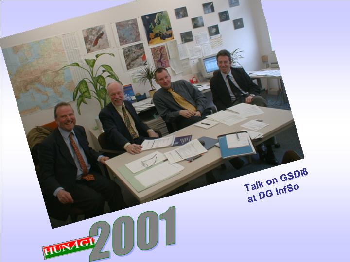
HUNAGI has participated the EUROGI Annual Board Meeting held on 20th March 2001, where also the EU Workshop on the Use of Cadastre to be held in Budapest between 7-9 June has been announced by Anton Wolfkamp, Secretary General of EUROGI.

Ian Masser, Anton Wolfkamp, Pascal Jacques and Daniel Rizzi at the DG InfSo in the break of discussions of the GSDI6 to be held in Budapest in September 2002.
· A two days visit has been arranged by the PARCELLA LTTA
· Dr..Richard A.Kidd, Detti Csonka staff member of FÖMI and DLM MARD for the experts of the European Commission DG Agri and DG JRC in CAP IACS issues. The venue of the first day was FÖMI RSC where the subject of the discussions was devoted to the technical details of Control with Remote Sensing as well as to the Land Parcel Identification System. The second day gave opportunity to exchange views, information with the decision makers of MARD and respective institutions. The new regulation prescribing the mandatory use of GIS after 2005 was also highlighted.

Mr.Jacques Stakenborg of DG Agri speaks on the IACS requirements related to controls

Mr.Guido Lemoine gave comprehensive views on CwRS and LPIS for the invited participants (about 30).


Left: Project leader Gabor Csornai highlighted the FOMI team’s results
Right: Dr.Celik and John Holmlund at the 8th Conference of the Turkish Surveyors
· By the invitation of the Turkish Surveyors Organisations, FIG Commission 3 (Spatial Information Management) has delegated John Holmlund (Canada), Gerhard Muggenhuber (Austria) and G.Remetey-Fulopp (Hungary) to deliver lecture at the closing plenary session of the 8th Conference of the Turkish Surveyors. FIG delegation paid a visit at the Office of the Turkish Cadastral Service as well as at the Chamber of Surveyors too. The Hungarian participants was selected by the recommendation of the UN ECE WPLA. The Hungarian presentation illustrated the challenging tasks having institutional development character to be solved in a country of the region in transition in Central and Eastern Europe, a country, which has the aim to complete the adoptation of the “Acquis Communautaire” of the European Union in the next one and half years. General statistics, the role and activities of the Lands and Mapping organizations were provided, highlighting the widening spectrum of the applications using advanced technology as operational services provided by FOMI. Special emphasis was given to the capacity building and knowledge transfer programmes as OLLO, SDILA and LIME (orchestrated by Prof. Markus of WHU CSLM) and the value of cross-border as well as international networking (Panel GI and ABDS). As an example among FIG (explicitly mentioned the Land Market WG lead by A.Ossko, Hungary), UNECE WPLA, ECAI and EuroGeographics also EUROGI was introduced as an interdisciplinary Umbrella Organization for Geographical Information on European level, which is open for new members, such as national GI association..
The Turkish Land Registry and Cadastre is looking for knowledge transfer and co-operation in mobility


Visiting the Director General Dr.Needet Poyraz of the Turkish Land Registry and Cadastre in Ankara. From left to right: Mr. Nihat SAHIN, Vice Dir. of TKGM, Mr.Hüseyin ÜLKÜ, President of TMMOB, Mr. J.HOLMLUND-CND,Mr.G.MUGGENHUBER-Austria, Mr.G.REMETEY-FÜLÖPP-Hungary, General Director of TKGM Dr.Necdet POYRAZ,Dr. Rahmi Nurhan ÇELIK - ITU Insaat Fakultesi Istanbul

President Hüseyin Ülkü, Secretary General A.Fahri Özten and Chief of international relations Muhittin Ipek of the Chamber of Surveyors in Turkey at the banquet given for the FIG delegation. The Chamber could be a potential interdisciplinary GI Association in Turkey.
· The National Cadastre Programme Non-profit Co has been accepted as major contributor to HUNAGI with full membership right. The acceptance is based on the resolution of the General Assembly of December 14, 2000.
· April 7 HUNAGI completed the questionnaire of Uta Wehn de Montalvo of the Science and Technology Policy Research, University of Essex Survey on the Hungarian experience with the implementation of the national spatial data infrastructure. Ms.de Montalvo was satisfied with the Hungarian contribution and HUNAGI will receive a copy of the final report prepared to the GSDI5 in Cartagena.
· April 10. HUNAGI submitted the news on the political debate on the wider use of GI on the expert meeting arranged by the Chair MP Balsay of the Committee of the Regional Development of the Hungarian Parliament to EUROGI for Europe-wide dissemina-tion. The Parliamentary Committee on Regional Development chaired by Mr.István Balsay held a meeting dealing with GIS on April 12. Using EUROGI’s effective information dissemination channel the news was distributed throughout in Europe before the meeting. Information was provided based on HUNAGI’s invitation by dr. Szabolcs Mihály, director general of FÖMI, and feedback on the news was received on the same day already from France.

The Hungarian Parliament Building
· April 10, JRC, EUROGI and HUNAGI finalised the Presentations of the EU Workshop on Cadastre to be held in Budapest between June 7-9, 2001.
· April 11 GIS-Day Coordinator Ms. Amy Thorson of ESRI found very exciting the topics of the planned professional content of the annual GIS –Day event scheduled for November 14, 2001. HUNAGI wrote:
Based on the definite success of the last year's event we have organised, the Theater Room having a capacity of 300 is reserved for November 14 in the historic building of the Ministry of Agriculture and Regional Development (just in opposite to the Parliament).
Last year we had the pleasure to have the dedicated videotaped message of Prof. Ian Masser, President of the European Umbrella Organisation for Geographical Information (EUROGI), as well as Dr.Jack Dangermond, "father" of this popular worldwide event.
The interdisciplinary national GI association HUNAGI arranges the event again in conjuction with its member Hungis Foundation. Major aim is to bring the age range 15-25 closer to the daily best practice where GIS is already used or could be used as a tool solving high priority problems achieving greater value for the society. Presenters as in the last years will be academicians, R+D, education and industry representatives, senior governmental decision makers as well as experts from NGOs.
This year the topics to be covered by the invited keynte speakers incudes e-content, how the public GI data can be made more accessible according to the e-Europe concept as well as how GI/GIS was already applied on national or supranational level related to global challenges as Agenda 21, Habitat +5 and Global Mapping.
This is timely, because Hungary will provide the venue of the 6th Conference on Global Spatial Data Infrastructure in Budapest September 2002 in a close co-operation of GSDI ExCom, EUROGI and HUNAGI.
· The 10th Anniversary of HUNGIS Founda-tion for the Advance-ment in Geo-informatics was celebra-ted by a reception. Hosted by the Teacher’s Club of the Budapest University of Technology and Economics on April 11, 2001 and was participated about 40 senior managers of the private sector, governmental officers, scientists and university professors. The establishment of the HUNGIS Foundation was aiming to contribute to the development of Hungarian GIS. It was the original idea of János Szilágyi () innovative leader and owner of the Europe-wide known Geometria GIS System House Company 10 years ago. The vision was immediately supported by academician Ákos Detrekői who serves as Chairman of the Board of Curators for HUNGIS since that time. The daily operation is managed by Executive Director Dr.Rezső Berencei. HUNGIS Foundation was among the first 7 founders of HUNAGI, the Hungarian GIS Association working in conjuction with HUNGIS.
The event was attended also by the Governmental Commissioner for Informatics at the Prime Minister’s Office Mr.Zoltán Sík, who emphasized in his address the effective role of GIS as a tool in numerous governmental programme implementations. HUNAGI President Mr.Zsolt Sikolya congratulated to HUNGIS Officers Detrekői and Berencei on behalf of the HUNAGI members and submitted a CD-ROM illustrating the past 6 years of HUNAGI’s activities in close co-operation with HUNGIS. The present also contained the printed version of the Koen van Biesen Report of the European Umbrella Association for Geographic Information.
Governmental Commissioner Mr.Zoltan Sík ® with Rector Ákos Detrekői acting as host (center) and Mr.Tibor Tenke
(l),
present leader of
 ·
·
State Secretary Dr. János Tardy, Head of the Office of Nature Protection of the Ministry of Environment opened the inter-ministerial expert meeting devoted to the River Tisza’s oxbows on April 12. The presentation of Mr. Tamás Margescu was participated by the potential stakeholders, i.e. representatives of governmental agencies and relevant departments as well as NGOs and the directors of three National Parks (Hortobágy, Bükk and Kiskunság). Ms.Tehmina Akhtar, UNDP Advisor for biodiversity and international waters of Global Environmental Facility from Ankara, Mr.Rastislav Vrbensky specialist in sustainable development policy as well as Dr. István Tőkés,
The importance of the use of GIS was underlined also by State Secretary Dr. János Tardy Chairman of the expert meeting .
Hungarian Liasion Officer were also present. A FIG report on the recent 8th Conference of the Turkish Surveyors dealing with GIS was submitted by SG of HUNAGI to Ms. Akhtar..
Mr. László Haraszthy, Director of the World Wildlife Fund Hungary was invited by SG of HUNAGI to consider the co-operation with the national GI association and to become member. An up-to-date information material on CD-ROM was submitted to WWF in order beeing familiar with HUNAGI’s mission goal, its activities in the past 6 years and action plan for 2001.

Messrs.Kálmán Morvay, representative of the Commissioner for
Tisza-Szamos, L.Haraszthy of WWF Hungary as well as Mr. József Hamar of the Tisza Club at the
meeting.
Below: Advisor and national representative of international donor organisation UNDP.

Debate on wider use of GIS within the Hungarian Parliamentary Commission for Regional Development
The information below is based on the ad-hoc summary written by Dr.Szabolcs Mihály participant at the experts' meeting of the Hungarian Parliamentary Committee for Regional Development, chaired by Mr.István Balsay MP on April 12, 2001. Quick release of this information was approved by Mr.Pál Vásárhelyi, Secretary of the Committee. Official Parliamentary version will be available in two weeks.
1.
According to the agenda, the Governmental Commissioner for Flood Protection and follow-on Actions of the Ministry of Transportation and Water Management gave thorough information on the events related to the historical floods of the River Tisza in March 2001. He pointed out the need for mid- and long-term water management strategies and the application of Geographical Information System (GIS) to support their implementation. Even during the conceptual planning phase and approval procedure, the use of GIS is inevitable and detailed surveys are needed. As a map base, digital topographic products are available (also covering the Upper Tisza Region, where the situation was the worst). An aerial survey of Hungary was completed within 3 months in Spring 2000 covering practically all of the country at an image scale of 1:30000. Also special large scale aerial photographs were required in the disaster area. He underlined the importance of geographic information as a major component of the national data infrastructure, especially for the future. The use of digital orthophoto products was said to be applicable and beneficial, also in the relatively flat Great Plain region.
2.
The Organisation of Catastrophe Management has been introduced. ARC/Info based GIS system is used for disaster mitigation. The system is well established, has an administrative boundary database and smaller scale topographic maps are used. It is critical is to ensure that the partners provide user-data to each other when updating and operating.
3.
Data, products and monitoring service capabilities provided by FÖMI during the flooding in March 2001 was presented. Dr. Mihály introduced thematic image maps and statistics based on an analysis of multi-platform satellite data, using digital topographic maps as a background layer. Visual interpretation of colour aerial photographs and orthophoto products taken and produced before the highwater period was also used.
4.
Conclusions related to the use of Geographic Information and GIS in the flood mitigation were summarised as follow:
- There is a lack of quality and accurate digital elevation model (DEM) with regard to operational functionality. DEM complements maps and imageries and is inevitable for the determination of elevation at certain terrain points or locations as often needed in decision support.
- Set up an application for a seamless satellite imagery database applicable for image processing, analysis and computer aided visual interpretation . It is anticipated, the user requirements will generate raising task volumes at the FÖMI Remote Sensing Centre.
5.
Recommendations by Mr. István Balsay, MP and Chairman of the Regional Development Committee of the Hungarian Parliament, included:
- The participating experts, national institutions and organisations such as Office of the Governmental Commissioner for Flood Protection, Catastrophe Management, Institute of Geodesy, Cartography and Remote Sensing, governmental stakeholders of the National Topographic Programme have a wide range of competency in this field.
- They should forward their proposals presented here to respective high-ranking politicians, e.g. their ministers, aiming at getting support for the use of GIS. This will not only support the case of natural disasters (damaging both human environment and economy) but also support using GIS on a constant basis.
The aim is to gain support for the GI/GIS programme in a wider political circle. Experts recommend to solve flood-problems by more intensive use of GI infrastructure. The Regional Development Committee of the Hungarian Parliament will submit relevant initiatives in this context to the Governmental Commissioner for Informatics at the Prime Minister's Office. The next meeting will be held in the Upper-Tisza region, probably in May 2001. It is expected that the Regional Development Committee together with high-ranking politicians will pay a visit also at the FÖMI facilities in the next future.
It is supposed that in water management more concerted actions are necessary to support GI-related activities at the inter-ministerial level, especially in application topics such as river management and agricultural water management.
The Local Organising Committee of the EU Workshop on Cadastre was arranged by LOC Secretary G.Remetey at the Department of Lands and Mapping at the Ministry of Agriculture and Regional Development on 18th April, 2001. The meeting was attended by Deputy Heads of the relevant MARD Departments on Plant and Soil Protection as well as Lands and Mapping, Messr. I.Fésüs and G.Horváth respectively, Dr.M.Ágfalvy, General Director of CLSM UWH, Ms.E.Kovács of FOMI, Ms.B.Csonka of Phare PARCELLA project, Mr.G.Ponicsán, Executive Director of the National Cadastre Program Non-profit Co. as well as dr.Rezső Berencei, Executive Director of Hungis Foundation. The meeting had the subject, how to support the local arrangements. The up-to-date Tentative Programme of the Workshop was also promoted on HUNAGI News section of the website of Hungis Foundation (www.hungis.hu).
Prof.Dr.Resmi Osmani, Dr.Bardhyl Qilimi and Ms.Viktória Vásáry at the DLM MARD.
 |
 |
||
Prof.Dr.Resmi Osmani, Director of the Directorate of Agriculture and Dr.Bardhyl Qilimi, Director of the Land Department of the Albanian Ministry of Agriculture & Food paid a visit at DLM MARD to discuss the Hungarian approach in Land Administration. Commissioned by Deputy Head Mr.G.Horváth, the guests were informed in details mentioning also the EU Workshop on “Use of Cadastre as component of the spatial data infrastructure in agricultural policy implementation”. The visitors were escorted by Ms.Viktória Vásáry of Szent István
University. The action was driven by GTZ Germany, locally arranged by the Research Institute of Agricultural Economics and Informatics
The Local Organising Committee of the EU Workshop on the use of Cadastre was arranged by LOC Secretary G.Remetey at the Department of Lands and Mapping at the Ministry of Agriculture and Regional Development on 3rd of May 2001. The meeting was attended by Dr.Géza Kőszegi, Head and Gábor Horváth, Deputy Head of the Department of Lands and Mapping, MARD. Messrsr. I.Fésüs Deputy of the Plant Health and Agri-Environmental Department, Dr.László Podmaniczky Vice-Director of the Environmental Management Institute of the Szent István University at Gödöllő were also present Ms. Erdélyi Erika of the Pest County Land Office,Dr.M.Ágfalvy, General Director of CLSM UWH. László Angyal of FOMI, Ms.B.Csonka of Phare PARCELLA project, Mr.G.Ponicsán, Executive Director of the National Cadastre Program Non-profit Co. as well as dr.Rezső Berencei, Executive Director of Hungis Foundation were also attended the preparatory meeting, concentrating on the logistics related to the poster exhibition and tehnical supports.
LOC Meeting EU Workshop on Cadaster hosted by the DLM
Below: G.Csornai presents the CropMon project results at AIK, at the Agro Intervention Centre’s CAP related seminar series.
Nincsenek megjegyzések:
Megjegyzés küldése