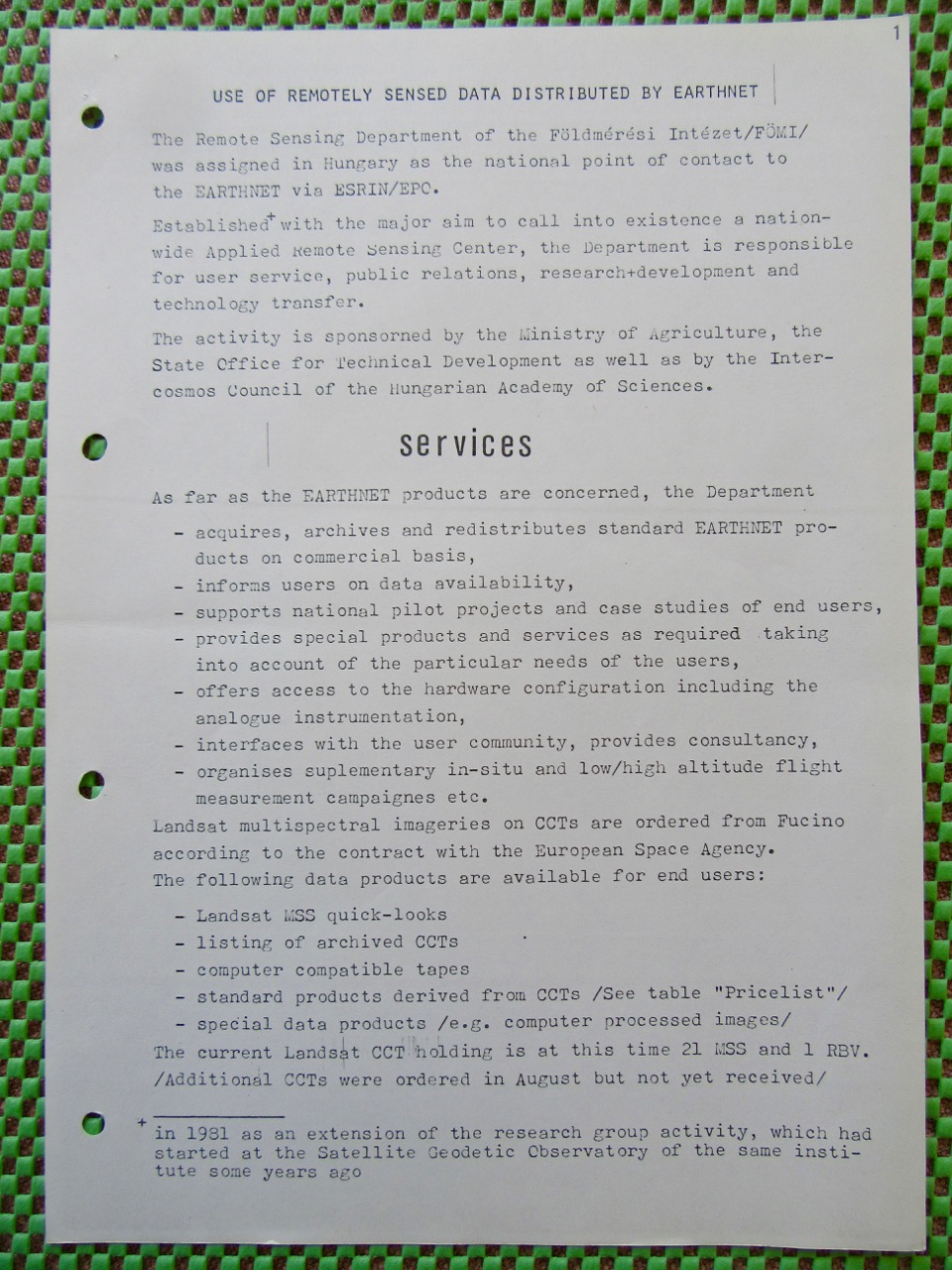
NTI- 14 Szakmai eseménytörténet, történetek

A térinformatika legutóbbi évtizedeinek hazai vonatkozású története bővelkedik eseményekben. Ez a napló helyt ad minden tényszerű közlésnek, hivatkozható publikációnak, amely segít teljesebb képet adni az elmúlt idők történéseiről. Várjuk a közreműködőket. A napló nyelve magyar, de archív összeállítások anyagai angol nyelven is megjelennek amennyiben magyar fordításban nem állnak rendelkezésre

2012-02-07

2012. év eseményjegyzéke

2012. február 7: ÁSZ saját honlapján szakmai partnerei között tartja nyilván a HUNAGI-t.

2011. év eseményjegyzéke

asap

2010. év eseményjegyzéke

2010-01-28

2009. év eseményjegyzéke

F
.

2008-04-16

2008. év eddigi eseményjegyzéke

Az eddigi illusztrált eseményjegyzék itt található: http://hunagi8.blogspot.com
Angol nyelven:: http://hunagi.blogspot.com
valamint www.unsdi.hu
HUNAGI URL: http://www.hunagi.hu
Mail: hunagi@hunagi.hu

2007. év HUNAGI eseményjegyzéke

A részletek itt találhatóak: http://hunagi.blogspot.com
HUNAGI URL: http://www.hunagi.hu
Mail: hunagi@hunagi.hu

2005. év HUNAGI eseményjegyzéke

Az anyag felvitele folyamatban. Az anyag letölthető a www.hunagi.hu honlapról.
Geospatial Hungary: http://hunagi.blogspot.com
HUNAGI URL: http://www.hunagi.hu
Mail: hunagi@hunagi.hu

2006. év HUNAGI eseményjegyzéke

Az anyag felvitele folyamatban. Az anyag letölthető a www.hunagi.hu honlapról.
Geospatial Hungary: http://hunagi.blogspot.com
HUNAGI URL: http://www.hunagi.hu
Mail: hunagi@hunagi.hu

2004. év HUNAGI eseményjegyzéke

Az anyag felvitele folyamatban. Az anyag letölthető a www.hunagi.hu honlapról.
Geospatial Hungary: http://hunagi.blogspot.com
HUNAGI URL: http://www.hunagi.hu
Mail: hunagi@hunagi.hu

2003. év HUNAG eseményjegyzéke

Az anyag felvitele folyamatban. Az anyag letölthető a www.hunagi.hu honlapról.
Geospatial Hungary: http://hunagi56.blogspot.com
HUNAGI URL: http://www.hunagi.hu
Mail: hunagi@hunagi.hu

2006-06-13

A 2002. év HUNAGI eseményjegyzéke - GIS Events of 2002

The Minister of Informatics and Communication introduces the NSDI in Hungary. (r to l: Prof Ian Masser, President of GSDI, Kálmán Kovács Minister, Elek Straub, DG of the Hungarian Telecom and Zsolt Sikolya, President of HUNAGI. Image: HUNAGI Visual Resources


A 2002. év HUNAGI esemény-jegyzéke - GIS Events of 2002

· GSDI6 LOC1 hosted by Academician Detrekői Jan 9
· Simulation of EU expert meeting on European Commission Proposal orchestrated by the Secretariat of the European Council – a training arranged by the Danish EU Institute organised by MARD January 14
· EESDI (later INSPIRE) final Working Group Arrangement – the Hungarian participation accepted. January 15
· EUROGI ExCom Apeldoorn,Jan 17-20
· GMES Open Day OM-MAFI Budapest,Jan 21
· Arrangement for GIS application for thematic mapping of Can industry and cooling facilities in the agrifood sector in Hungary to be produced by FOMI for the Agrifood Department MARD (A.Palotas) January 22
· Nomination for E-ESDI/INSPIRE Initiative Working Group' Hungarian members have been accepted by the European Commission DG JRC January 23
· Preparation of the Tisza Agreement hosted by the Ministry of Foreign Affairs HUNAGI member FOMI has provided a Satellite Image Map on the Carpathians for the Department of Regional Relations Jan 24
· EU BioCASE project call (having GIS content) disseminated by HUNAGI: The Institute of Bothany of the Hungarian Academy of Sciences at Vácrátót interested. January 25
· HUNAGI disseminated the information of the BRGM Open Day on the use of GIS and thematic mapping in Central and Eastern European countries in mineral resources and environmental applications. HUNAGI members attended the discussion hosted by the French Centre. Leaflet on HUNAGI has been distributed. January 29
· Tisza River Vasarhelyi Plan Development (Meeting hosted by the Agricultural Water Management Department of MARD) Importance of the interoperability and SDI was underlined.from the EWF viewpoint February 7
· HUNAGI was found as potential partner in the implementation of the Center of Excellence project to be supported by the World Bank based on communication with Word Bank Regional Office experts F.Kaps and V.Gyuris. Budapest February 7
· Invited lecture abstract on the Flood mitigation supported by RS/GIS prepared and sent to DLR German Aerospace Establishment. February 15
· HUNAGI has submitted the selected points of contact for the different topics of the EU supported project Geographical Information Network Infrastructure for Europe (GINIE) managed by Max Craglia (University of Sheffield) and coordinated on EUROGI side by Chris Corbin, member of the Executive Committee, Executive Director of AGI (UK) Feb 15
· HUNAGI was represented at the AGI- Orthophoto expert discussion in London by P.Winkler, Deputy Director General of FÖMI (member of HUNAGI) Feb 15
· Hungarian ISPRS National Committee Correspondent for the Commission VII was asked to prepare the supporting letter of ISPRS application for full membership in ICSU, Paris to be sent via academicians Detrekői and Ádám and the President of the Hungarian Academy of Sciences to Mr.H.Yoshikawa, President of the Executive Board. February 18.
· HUNGIS Meeting of Board of Curators hosted by the Rector I.Klinghammer at the Department of Cartographic Sciences L.Eötvös University (member of HUNAGI) Feb 19
· GSDI6 sponsors raising meeting organised by HUNAGI, hosted by I.Feczkó of MATAV Department of Governmental Relations Feb 21
· HUNAGI was represented at the DDGI-NRW-Conf GI Data Mgnt by Ms.E.Kovács of FÖMI (member of HUNAGI) Bonn Feb 22
· Conference on Land Fragmentation in the CEE Munich, The importance of GI/GIS was underlined in the Munich Statement. HUNAGI leaflet was distributed for selected participants incl. Prof. Holger Magel, incoming President of FIG. Feb 25-28
· HUNAGI-Autosesk Ltd. (represented by M.Pósfai) agreement on the planning and implementation of the GSDI6 site specific information (News from the host) March 5
· Spain-Hungarian twinning on Agrostatistics (Lucas) Leaflet on HUNAGI has been distributed March 6-8
· HUNAGI participation at the ETeMII High level Hearings by invitation of the Project. Antwerpen, March 6-7. Leaflet on HUNAGI has been distributed
· HCSO-ESTAT-MARD-FOMI Meeting on Agrostatistics (Feasibility of Hungary’s participation in the LUCAS 2002 programme) March 6-12
· GIS Open Conference Széfesfehérvár March 11-13, with presentation on GINIE and INSPIRE on March 13
· EUROGI Executive Committee Meeting, City Hotel, Luxemburg, March 16
· EUROGI ExCom, Member’s Day, AGM March 17 at theJean Monnet Building of the European Commission
· EUROGI Assembly General Meeting. HUNAGI presentation on the concept of its invited presentation at the First Congress on Cadastre in the EU entitled: Cadastral GIS in the EU. HUNAGI presentation on the preparatory works related to GSDI6. European Commission, Luxembourg, March 18-19
· FGDC-EUROGI-HUNAGI talks on GSDI6 in Luxembourg, March 19
· HUNAGI presentation at DLR Seminar on flood mitigation related RS/GIS applications in Hungary prepared by FOMI. Seminar chaired by H.Seipel, DLR Bonn-Oberkassel March 21.
· FÖMI expert Cs.Wirnhardt takes part on the Impact WG of INSPIRE in Brussels, March 26
· Tisza River Project driven by Hunagi member MAFI March 27,
· GSDI6 LOC2 March 27 hosted by DLM MARD participated by the Assistant of the Secretary Genaral of EUROGI
· Prep meeting Congress Ltd, EUROGI and HUNAGI March 28
· Meeting of EUROGI President Ian Masser,Assistant Secretary General K.Levoleger and LOC Chair academician A.Detrekői HUNAGI President Zs.Sikolya at the Budapest University of Technology and Economics on March 28
· HUNAGI was invited to arrange jointly an Open Day devoted to Earth Observation in conjunction with the hungarian Space Research Office and the European Space Agency in Summer 2002. First contact on March 29
· World Bank Regional (ECA) Conference on Land related issues. Importance of GIS underlined by F.Simon of the European Delegation. Also the Regional Centre of Excellence in Land-related knowledge transfer to be establishedin Budapest supported by the World Bank and MARD was introduced. Budapest April 4-6
· Altavista HUNAGI Internet references: 772 on 237 websites as of April 6, 2002
· ESTAT LandUse/Land Cover WG HUNAGI leaflet and GSDI6 promotion for e.g. GAF, Germany. April 8-9
· Commemorative exhibition Space Cooperative Agreement between NASA and Hungarian Space Agency. Poster contributions have been provided by the Hungarian Space Agency and FÖMI, both members of HUNAGI. Cleveland April
· GSDI6 prep meeting with MATAV April 16
· FIG Congress participated by several HUNAGI core members as UWH Geoinfo, FÖMI and the Capital Land Office in Washington, April 20-26, 2002
· 3th INSPIRE Expert Meeting, Palacio de ZurbanoMadrid April 29-30
· Google search engine showed 735 references for HUNAGI in the Internet May 2
· Prof.B.Markus, Director of the College Geoinfo UWH became Member of AGILE Presidential Board. May 7
· Land Consolidation GuidelinesDrafting Workshop FAO HQ, HUNAGI leaflet and GSDI6 was introduced for some members of the Drafting Working Group. Rome, May 9-10
· HUNAGI was requested to provide partners in waste management GIS application (Phare project) from abroad May 11
· First Cadastral Congress in the EU. Presentation on behalf of EUROGI on Cadastral GIS in the European Union, some EFTA and CEE candidate countries. Granada May 15-17
· HUNAGI officer was also invited by N.Land, Executive Director of EuroGeographics to the project proposal bid for Eurostat. (TheEuroGeographic bid was lost only due to the higher financial offer as reported) May 17
· GSDI6 LOC3 Meeting, May 21 hosted by the Office of the Governmental Commissioner for IT at the Prime Minister Office
· MAGISZ Agroinformatics Conference Organising Committeee Meeting hosted by AKII, Budapest, May 27
· HUNGIS Board meeting Budapest May 28 hosted by the Rector of the Budapest University of Technology and Economics on
· Kaposvár GIS Conference on Role of GIS in the transformation of the agricultural structure and in rural development – Data providers and users. Special session devoted to Precision Farming (organised by HUNAGI member Kaposvar University, Institute of Mathematics and Informatics), May 30 Sz.Mihaly of FÖMI delivered a lecture on the European Union’s Statement on Cadastre, while G.Remetey talked about the Munich Statement for the over 100 participants.
· HUNAGI was introduced firstly by the new serie of the EuroConnexion journal (UK) among the National GI Associations May 2002
· Geodézia Ltd. offered a technical Excursion for the GSDI6 as sponsoed action. May 30
· G.Demszky, Mayor of Budapest accepted the invitation to give reception for the participants of the GSDI6. May 31
· Inviting the Hortobágy National Park to join HUNAGI during the FAO factfinding mission along the Middle and Upper-Tisza (subject: land management in endangered areas) June 4-5
· 9 new UNIGIS postgraduates at the Debrecen University (GIS in agroinformatics) June 10
· World Bank NGO Working Group for CEE, Poster presentation at the NGO Knowledge Forum June 14-16, Belgrade
· HUNAGI was introduced for members of the EC Peer Review Delegation on CAP IACS visiting MARD/FOMI on 17-18 June, 2002
· GSDI6 was introduced to J.Linn, Vice President of the World Bank. The availability, access and usability of GI was emphasized and adopted by the 200 delegates from 28 countries at the 2nd ECA NGO Assembly “Civil Society Driving Development : Experiences and Future Prospects”. Beograd, June 12
· HUNAGI has submitted two GI/GIS appication for INSPIRE (flood mitigation and Logwater mapping and monitoring) which have been accepted by the DG Envi June 18
· 4th EFITA 2003 AgriFood Informatics Conference Budapest-Debrecen(5-9 July, 2003) HUNAGI has disseminated the First Announcement received from Paris, June 28
waksman@acta.asso.fr More information: efita2003@date.hu Conference
· FÖMI RSC provides GIS/RS based information at the fire in the Hortobágy National Park June 28-29
· BlomInfo Consortium (member of HUNAGI) completed its Phare mission in GIS supported Vineyard Statistics
· INSPIRE 4th Expert Meeting, Referring to the Hortobagy fire related experiences of FÖMI RSC on 28 June, HUNAGI raised the need for an Internet based guided emergency check list and guided navigation for the most reebvant data access and use. Dublin Castle, July 2
· 8th EC GI/GIS Workshop, Dublin July 3-5 DG JRC-EUROGI-HUNAGI joint paper presented by R.Waters. The Hungarian delegation included Zs.Sikolya, President of HUNAGI and a 10 member group of the Phare project META (the County-level IT development of the Land Offices orchestrated as technical visit by T-Systems, principal contractor)
· G.Remetey was invited by the DG JRC to serve as co.-chair in the session of EU GIS projects July 4
· HUNAGI has submitted three grant applicatiions to the R+D Deputy State Secretary of the Ministry of Education for partial support related to theGSDI6 conference, the EUROGI annual membership and the Hungarian participation at the ISPRS mid-congress symposium of the Commission VII devoted to Resource and Environment Monitoring. July 12.
· On the inquiry of Eurocities, experts of VATI and FOMI recommended by HUNAGI on July 8 for the Eurocities Project Review Meeting to be held in Brussels on 17-18 September, 2002
· The 34th UDMS Conference (Prague, October) was promoted by HUNAGI in the GIS community with success · GMES FORUM First Conference on Global Monitoring for Environment and Security Brussels, 15-17 July 2002
· GSDI6 LOC4 Meeting, July 16 at Congress Ltd.
· HUNAGI will be introduced for members of the EC Peer Review Delegation on Vineyard Cadastre visiting MARD/FOMI on 17-18 July
· The application for Public Benefit Association has been submitted for the Budapest Court for approval on 10th August, 2002.
· HUNAGI made promotion for the GSDI6 via the ISPRS, the Eurocities, the Urban Remote Sensing and the Urban Communities in earrly August. Until 14th August 140 participants from 35 countries of 5 continents made application for registration for the GSDI6.
· HUNAGI and Congress Ltd. made in-depth proof of the 98 pages GSDI6 brochure printing draft on 7th and 14th August.
· HUNAGI supportive letter issued on 10th August was attached to the bid of Diputacion Provincial de La Coruna (Spain) for hosting the 9th European Commission GI/GIS Workshop as reported by representative Mr.Gonzales Pérez.
· On 16th August HUNAGI shared the Elba flood GIS application information received via the egip-list contributor Prof Hoffmann from Dresden with HUNAGI members and potential service provider FÖMI RSC.
· GEO2002 Conference of Hungarian Geoscientists Sopron, 21-25 August. Poster on INSPIRE
· GSDI6 LOC5 Meeting, August 26 at the Institute of Geodesy, Cartography and Remote Sensing (FÖMI)
· Agroinformatics Conference with sessions devoted to GIS organised by Prof.Miklós Herdon of the Debrecen University Agroscience Centre and the Hungarian Agroinformatics Federation (MAGISZ), both members of HUNAGI August 26-27 Debrecen. Presentation was made on INSPIRE in the session chaired by HUNAGI Secretary General. Dr.Péter Bakonyi, Under Secretary at the Ministry of Informatics and Communication was informed on the HUNAGI activities with special emphasis on the coming GSDI6 conference.
· Open Day on European Space Agency’s enlarged partnership programme PECS organised with Hungarian Space Research Office on ENVISAT and Earth Observation Budapest, September 5-6 hosted by HUNAGI at the Ministry of Agriculture and Regional Development, opened by the Head of the European Integration Directorate Dr.László Vajda of MoARD (as of September 4, about 50 registrants of more than 30 institutions and MSEs have been registered)
· Final (6th) formal GSDI6 LOC Meeting, September 9 chaired by Prof.Detrekői, hosted by the Department of Lands and Mapping (Head: Mr.Géza Apagyi), Ministry of Agriculture and Regional Development.
· GSDI6 On-the-spot-Meeting arranged for the technical organisers by MATAV project Manager István Oláh on behalf Iván Feczkó Head of Governmental Relations Department, September 10, attended by the representatives of all active collaborators (Haitec, IBM, Axelero, BNC, Congress, HUNAGI, Autodesk). Finalisation of the detailed installation layout and timing, system plan and communication hotlines.
· HUNAGI was requested to recommend representative of the GIS/LIS private sector for the Advisory Committee of the Regional Centre of Excellence on Land and Property Rights and Land Market Development - a project launched by MoARD with World Bank support.
· UNECE WPLA Workshop, Vienna, September 10-12
· The Brussels based Eurocities Organisation has invited via HUNAGI Mr.István Ferencsik of VÁTI to attend the Benefits of Urban Green Space Workshop organised by Eva Banos Head, Eurocities with the support of Me. Annemarie Renard, "Director-adjoint du Bureau de Liaison Bruxelles Europe" and Me. Caroline Mancel, from the External Relations Department of the Ministry of the Brussels Capital Region, who have both facilitated that the Brussels Capital Region hosts this workshop between 17-18 September 2002. Experts from the following cities will participating the Workshop:
· 1. Bologna: Giovani Fini 2. Bristol: Debbra Abraham 3. Budapest: István Ferencsik 4. Essen : Gerhard Effgen 5. Goteborg: Björn Malbert 6. Lichfield (Staffordshire): Karen Sims-Neighbourg 7. Lodz: Anna Wolowska 8. Munich: Jörg Weber 9. Newcastle: Liz Bray 10. Regensburg: Carsten Juergens 11. Rome: Mauro Selemini 12. Utrecht: Peter Schildwatch 13. Zaragoza: Victor Bueno
· Link to the latest Bugs document is:
http://www.vito.be/bugs/
· 6th Global Spatial Data Infrastructure Conference September 16-19 supported by the EC DG InfoSo by IST grant (as of 20th September, over 230 participants from 55 countries have been registered from all over the world.)
· Legal and Interoperability pre-conference workshop (free to GSDI6 registrants) 16th September including:
· Spatial Data Infrastructure Legal and Policy Issues I. An Overview
· Spatial Data Infrastructure Legal and Policy Issues II. Providing services and addressing legal barriers in the virtual era – Best practices from Europe
· Interoperability in GSDI – standards, soulutions and futures
· Interoperability showcases: standards in actions
· Burning issues – presentation of EUROGI national GI association: AESIG Spain Sebastian Mas Mayoral, AGI United Kingdom Ian Masser, CAGI Czech Republic Josef Hojdar, DDGI Germany Waechter, HUNAGI, Hungary Zsolt Sikolya and Gabor Remetey-Fülöpp
The conference presentation included 6 lectures delivered by experts of 4 HUNAGI member institutions: FÖMI (Sz.Mihály, P.Winkler, G.Csornai and Gy.Büttner), MoD Mapping Co. (L.Alabér), HungaroCAD (L.Bakos) and PMO (Zs.Sikolya).
Informal lunch-talks organised by HUNAGI and the Ministry of Education for Ministerial Dirigent Christopher Patermann (DG Research), Marc Vanderhaegen (DG Envi), Alessandro Annoni (DG JRC) and FÖMI SDI specialists 19th September 2002.
Post-conference event supported by the arrangements of HUNAGI or HUNAGI members:
· Daily GSDI Steering Committee Meetings prior and during the conference (closed shop)
· Meeting of the Board of Directors of the Open GIS Consortium Meeting Budapest Hotel Mercure Buda, September 20 (postponed)
· Full day Post Conference Technical Excursion sponsored by Geodézia Geoengineering Ltd to the Paks Nuclear Power Station Visitors and Information Center. Presentations include highlights of the PPP Tolna County Land Office and Geodézia Ltd. Social meeting at the Fritz Cellars. Attended by 20 participants of the GSDI6 from Hong Kong, Norway, Denmark, USA, India, The Netherlands, Albania, United Kingdom and Hungary September 20
· Full-day ISCGM Steering Committee Meeting Budapest, hosted by the Ministry of Agriculture and Regional Development September 20
· INSPIRE Working Group Chairmens’ Meeting with representatives of the European Commission. Hosted by FOMI, September 20 (Closed)
· Hungarian participation on the AGI Conference in UK (Ms.Agnes Kummert of Bonaventura Ltd, member of HUNAGI. Sponsors: HUNGIS Foundation and HUNAGI).
· HUNAGI won a 3500 euro grant by competition of the Ministry of Education, Under-secretariat of Research and Development to cover 50% of the annual EUROGI membership fee. September 23, 2002.
· HUNAGI members (HSO, TTTC, etc) listening the lecture delivered by Dr. Gene Kranz of NASA Apollo 13 Mission: at the Hungarian Academy of Sciences on September 24, 2002
· HUNAGI leaflet was submitted to Ms.Nina Maria Fite, Regional Environment, Science and Health Officer of the US Embassy at Budapest,
the HUNAGI CD-ROM to her Excellency Ms.Nancy Goodman-Brinker, Ambassador and the Annual Report of the National Mapping Activities to Ms. Janet E.Garvey, Deputy Chief of Mission of the Embassy at the reception given to in honour of Embassy key interlocutors on 25th September.
(The Ambassador will also receive the archived live-internet videostream of the GSDI conference produced by the MATAV via Ms.Marianna Posfai of Autodesk, sponsor of the conference)
· Introduction was given and background materials were submitted to the German delegation at the meeting of the Hungarian-German Agrarian Management Board hosted by the Ministry of Agriculture and Rural Development on September 26, with special emphasis on the information exchange-based links between DLM MARD and the NorthRhein Westfalia Surveying Authority in the field of GIS/GI related activities and policies.
· GINIE Workshop on EU Enlargement related issues Prague September 29-October 1 was participated by Ms.Katalin Toth of FOMI delivered presentation on the Hungarian GINIE-related situation and distributed info material on the Regional CoE on Land &Property Right under establishment.
· Report on the National Mapping Activities in 2002 prepared by MAHDF, DLM MARD and FÖMI, as well as information on the GSDI6 Conference, and the regional CoE on Land &Property Right was available for the participants of the EuroGeographic Annual General Assembly held in Frankfurt am Main September 30 - October 2. Nick Land, Executive Director of EG and Bozena Lipej of the UNECE WPLA have received personal copies of the HUNAGI information material.
· Oktoberdesk. Open Day of Autodesk on Geo-informatics and civil engineering. Stefania Palace, Budapest October 8: 6th GIS Workshop Cluj-Kolozsvár, October 16-18
· EUROGI ExCom Meeting hosted by the Dutch Kadaster in Apeldoorn October 9
· Land Use Working Group Meeting hosted by EUROSTATReport on the orthophoto supported LUCAS area-frame sampling based European Land Use Survey, the early results in Hungary achieved by HCSO and FÖMI. October 10, 2002
· Meeting of the Curators, HUNGIS Foundation Hosted by Geometria Ltd. October 15
· FAO Reception, meeting with the new Director of the Subregional Centre Budapest, October 15
· FAO International Workshop on Land Tenure Budapest, October 23-24
· Presidential Board Meeting of HUNAGI hosted by the Prime Minister’s Office. October 25
· Information leaflet on HUNAGI was distributed for participants of the Conference on GIS in Higher Education hosted by St.Stephen University Faculty Buda (member of HUNAGI), October 30
· Sponsored by Autodesk Ltd, Proceedings of the GSDI6 has been compiled, edited and submitted to the websites of
http://www.eurogi.org/ and http://www.hunagi.hu/
· Some of the county level Plant and Soil Protection Services expressed their interest to join HUNAGI in November 2002
· HUNAGI contribution to the GINIE Europa-wide survey on National GI Asssociations November 2002
· The role and importance of spatial data infrastructure was highlighted and submitted to State Secretary Dr.Tibor Szanyi of MoARD for his presentation at the Conference on e-Government held in Balatonaliga, 13-14 November, 2002.
· The 12th National GIS Conference November 14-15 organised by the HUNGIS Foundation and sponsored by HUNAGI in Szolnok. Presentations include topics on GSDI and INSPIRE (G.Remetey), PSI (Zsolt Sikolya) and GINIE (Ms.Katalin Toth)
· This year HUNAGI members Dept. of Cartographic Science, Eötvös L. University and the College of Geoinformatics of the West Hungary University arranged events supported by ESRI Hungary in Budapest and Székesfehérvár respectively on November 20, 2002
· Space Day organised by MANT and MŰI, hosted by ELTE on November 20
· HUNAGI response on the GINIE questionnaire update of the National GI Association profile.
· Presentations and Chairmaship were given by HUNAGI member representatives FÖMI, Nat.Cadastral Program Pbc. And Budapest Land Office at the conference Property Registry vs. Landbook” with topics Integrated land registry and cadastre, European cadastral systems and the RCoE LandNet respectively. Event organised by HUNAGI member MFTTT on November 22-23 at Sunlight Hotel in Budapest.
· Dr.István Márkus of the University of West Hungary, Chair of Surveying and Remote Sensing was invited as special guest representing HUNAGI at the Annual Conference of AGEO, our partner national GI Association in Austria. The conference - held at the Vienna Technical University on November 28 - was devoted to the topic Geo-government.
· HUNAGI profile description was prepared for the Hungarian Delegation lead by State Secretary for Land Tenure Policy Dr.Fülöp Benedek for his official visit in Beijing, China on Land isssues. December1-7, 2002.
· HUNAGI was represented at the AGEO Annual Conference devoted to the subject „GEO-government” hosted by TUV on 28th November 2002
· HUNAGI leaflet has been submitted for interested participants of the ISPRS Commission VII Symposium (WG VII/4 is lead by Hungary and Germany on topics Human Settlements and Impact Analysis), where G.Remetey have delivered as chair of two sessions two lead talks (on GIS/RS documentation of World Heritage Sites and High resolution satellite remote sensing potentials for urban analysis respectively) in Taj Krishna at Hyderabad, December 2-6, 2002. The presentations - based on contribution and kind assistance of HUNAGI members VÁTI, FÖMI and Telespazio as well as EURIMAGE - will be available on HUNAGI website. The Summer School on GIS in Land Management organised by the College on Geoinformatics of the university of West Hungary in co-operation with ITC, Enschede was also highlighted at the meeting participated by ISPRS Council members, technical commission presidents and working group chairperson on December 4.
· General Board Assembly was held on 16th December 2002 hosted by MoARD
· HUNAGI leaflet has been prepared for interested participants of the Regional Centre of Excellence - property Right and Land Market Development. Open day for the representatives of some EU Member States and Candidate Countries in Budapest December 18, 2002 Attendees: SLN, RO, PL, FR, AU, informed: SP, DE
· HUNAGI leaflet has been disseminated to participants of the Meeting of Heads of the County Land Offices and county contact personels of the National Land Fund. December 19, 2002
· HUNAGI leaflet was submitted to manager Ms.Imola Juhász and management consultant Mr.Ulrich Sprenger, representatives of Skycontroll Ltd. in the occasion of their visit at DLM MoARD devoted to the offered products and services in high resolution satellite imaging of ImageSat International on 20th December, 2002
· HUNAGI leaflet was conveyed to the representative of DLG Mr.J.Damen, during his visit at the DLM MoARD devoted to the bilateral programme related to land consolidation on 20th December, 2002

Geospatial Hungary: http://hunagi.blogspot.com
HUNAGI URL: http://www.hunagi.hu
Mail: hunagi@hunagi.hu

2006-06-12

A 2001. év HUNAGI eseménytörténete - GIS Events of 2001


A 2001. év HUNAGI esemény-története - GIS Events of 2001

Eseménytörténet, ahogy azt abban az évben a HUNAGI összefoglalta:

  • Registration of the Data Property of Public Administration in Hungary
    In order to promote the access to public interest information managed by public administration and the better exploitation of the data property of public administration as a key resource, a government resolution has been signed by the Prime Minister in Hungary on the Registration of the data property of public administration. The resolution is dealing with the free access to the key characteristics of data sources and related concepts on a public network as well as of querying the access information of data sources. According to the resolution, a framework system for the registration of public administration data property was created by 31 January 2001.
    After the initial loading of data (deadline: 30 June 2002), the continuous updating of the public administration data property register will be assured by the provision of the required resources, including regulatory, organisational, professional and other prerequisites of the commencement and maintenance of the service. By the way, the voluntary accession of all municipal and other public bodies to the public administration data property register will be facilitated.
  • The ABDS for the CEEC project, aiming at the preparation of an on-line service of administrative boundary data of the region has successfully accomplished its task – it is the main result of the EC review of the project held on 18 January 201 in Prague. As it was stated by the reviewers, Maciej Podemski (Poland) and Vincent Dessard (Belgium) the project achieved good results in tracing the structure of administrative hierarchy and of the change registry procedure in the countries of the CEEC region; elaborated and tested generalisation/simplification methods for compiling the ABDS products according to unique specifications; and built a competent network of specialists of mapping and statistical organisations. Moreover, the pilot project implemented in Hungary took the first steps towards an on-line real –time service. The results of the project and the expression of willingness for further collaboration were summarised in the Memorandum of Understanding, signed by representatives of Finland, Estonia, Latvia. Lithuania, Czech Republic, Romania, Bulgaria, Greece and Hungary. However the implementation of the service depend on many different factors. Besides of financing the most important thing is the interaction within the SABE and the future ABDS products. The teams of EuroGeographics and ABDS already has started about harmonisation of their activities. For more information please contact Ms.Katalin Tóth via abds@fomigate.fomi.hu
  • The Hungarian Association for Geo-information was among the five European national GI associations (AFIGÉO, DDGI, AGI, RAVI and HUNAGI), which were interviewed on the spot and evaluated based on careful selected modelling by Mr.Koen van Biesen, expert of EUROGI in the last Quarter of 2000. The early results of the comparative study were discussed at the Executive Committee meeting of EUROGI in Apeldoorn on 19-20 January 2001. HUNAGI was found as a good example, how a GI association with a very limited budget can operate efficiently.
  • In June 2001, the first EC Workshop on the use of cadastre will be hosted by the Hungarian GI Association (HUNAGI). The technical programme organised by the EC DG JRC SAI and the European Umbrella Organisation for Geographical Information (EUROGI) HUNAGI will be devoted to the issue, how cadastre as component of the national spatial data infrastructure can support the agri-environmental policies. The participants will have excellent opportunities to take part technical visits organised tentatively on sites related to different aspects of the Land Administration general and value-added service to support agri-environmental policy eg. land tenure tools for rural development in small regions, advanced education on land management, CAP institutional development (LPIS), Cadastre based Control with Remote Sensing etc. JRC has already organised the 4th EC Workshop on GI in conjuction with HUNAGI successfully three years ago. The tentative programme is in the Chapter devoted to Events in 2001.
  • By the invitation of Under State Secretary Dr.Z.Kovács, a delegation Mr.Sönnichsen Dr. Elke Halm Rüdiger Evert lead by State Secretary Dr. Frank Tidick from Mecklenburg-Vorpommern has visited MARD on 25-26 January, 2001. The German experiences have been highlighted during the duscussions with 40 invited Hungarian experts with special emphasis on the village renewal, land consolidation and the management of land funds.
  • 6th GSDI Conference – back to Europe – to Hungary. After Chapel Hill (North America), Sydney (Australia), Cape Town (Africa) and Cartagena (South America) Budapest will be the site of the 6th Global Spatial Data Infrastructure Conference.. This proposal was made by EUROGI based on evaluation of bids in competition environment and agreed by the GSDIl. The very first GSDI Conference was held in Europe, hosted by DDGI near to Bonn in Bad Königswinter in 1996. HUNAGI was represented at the meetings without interruption. The official press release is found in the Chapter devoted to the Events.
  • Special Issue of the Journal “World of Nature” devoted to the Space including Earth observation and GIS
    · A special issue will be published in the Spring 2001 orchestrated by the Hungarian Space Research Office containing a series of state-of-the-art comprehensive articles covering topics including economic benefits of the space activities in
    · Agricultural yield estimation
    · Environmental applicatons
    · Use of EO in mapping and urban management
    · Space activities and the GIS
    · Satellites and weather forecast
    · Thematic maps on energy balance
    · Surface properties determination using satellites
    · Use of meteorological image interpretation for short term forecasting
    · Wider use of space-based telecommunication
    · Satellite navigation tuday , tomorrow and later
    · GPS applications in Hungary
    · Space and life sciences
    · Quality requirements in the space research
    · Role of industry in the space activities
    · Dosimetry - Pille (on the Space Station)
    · Space and the impact on material sciences (UMC)
    · Education and space policy
    · Education, training and awareness raising in Hungary
    · The institution of the Hungarian Space Research and its international links and future plans
    · Highlights of the Space in the 21st Century
    · Space literature in Hungarian language
  • Prepared by EU Phare expert dr.Richard A. Kidd a MARD-FÖMI delegation has visited DG JRC SAI MARS team in order to exchange view in topics such as CwRS, LPIS and AEMs.
  • Between February 26-28, the countrywide visiting of the pilot sites of the computer (GIS) based land consolidation programme was performed by project manager Dr.Wolfram D.Kneib. Stopover of the round trip were in Bakonykúti, in Dabrony (Three Brooks Small Region), Gamás (Balaton Park 2000 Small Region), Kaposvár (Web-based GIS service provided by Kör Ltd) and Sásd (Hegyhát Rural Development Small Region). Country Co-ordinator of the TAMA project Dr.P.Riegler has arranded a farewell meeting for Dr.Kneib in Boly/Fenékpuszta, where the overall consequences and recommendadtions of the 7-years long project have been discussed with all of the leading experts of the participating County and District Land Offices.
  • Preparation has been started for the participation of the UNECE WPLA Workshop on Land Administration and the EU accession will be held in Gavle, Sweden
  • Financial documents related to the multiyear SAPARD framework have been signed by MARD State Secretary dr.Károly Tamás and dr.Jenő Varga, Minister of Finance with dr.Franz Fischler, Member of the European Commission, head of the DG Agri in Brussels, on 1st March, 2001.
  • PRESS RELEASE January 25, 2001
    Budapest to host sixth Global Spatial Data Infrastructure Conference
    Seven years after the first of what has now become a regular series of Global Spatial Data Infrastructure Conferences was held in Bonn under the patronage of EU Commissioner Martin Bangemann this important event will return to Europe next year. At its meeting on January 24th 2001 the Steering Committee of the GSDI conference unanimously agreed to the proposal put forward by EUROGI President Ian Masser to hold the sixth GSDI conference in Budapest in September 2002. The conference will be organised the Steering Committee in conjunction with EUROGI and HunAGI the Hungarian national geographic information association.
    The decision was the outcome of a competitive bidding process organised by EUROGI for its national member associations. HunAGI warmly welcomed the news that the GSDI will take place in Budapest. In the opinion of its Secretary, Dr. Gabor Remetey Fulopp, ' It is really a great pleasure and honour for HUNAGI and the whole Hungarian GI community. This challenge will have surely an anticipated spin-off effect providing positive impact on the acceleration of the spatial data infrastructure building related programs here.'
    The EUROGI secretariat has already had preliminary discussions with EU officials regarding support from the Commission for this event. Now that the location of the Conference has been agreed the next round of discussions can get under way so that detailed proposals can be presented to the Steering Committee at the fifth GSDI conference in Cartagena, Colombia in May 2001.
    EUROGI is the EURopean umbrella Organisation for Geographic Information. It has more than 20 national and pan European GI associations as members. In this capacity it represents over 3000 separate organisations in 20 different countries.
    Its mission is to maximise the effective use of geographic information for the benefit of the citizen, good governance and commerce in Europe and to represent the views of the geographic information community in discussions with the European Union and other bodies.
    GSDI is a global and open process for co-ordinating the organisation, management and use of geospatial data and related activities. It encompasses the policies, organisational remits, data, technologies, standards, delivery mechanisms, and financial and human resources necessary to ensure that those working at the global and regional scale are not impeded in meeting their objectives.
    GSDI is being advanced through the leadership of many nations and organisations represented by a GSDI Steering Committee. This multi-national Steering Committee includes representatives from all continents, and all sectors - government, academia, and the private sector. The Steering Committee has identified a set of core goals to help advance awareness, acceptance and implementation of globally compatible spatial data infrastructures at the local, national, and regional levels:
    · Articulate the operational environment needed to achieve Global SDI compatibility
    · Help build globally compatible SDI capacity around the world
    · Educate decision-makers on the benefits of GSDI inside and outside their borders
    · Assure that different SDI related policies can be facilitated by the GSDI
    · Advance the GSDI mission until a global SDI is achieved
    Further information Contact Anton Wolfkamp or Karen Levoleger at the EUROGI secretariat.
  • On behalf of the Dutch Ministry of Economy Reviewer Drs Titia H.C.Slis of the Senter International and Jack Damen of DLG have discussed the land consolidation supported integrated rural development project proposal of the MARD. The project emphasise GIS based approach used by the 7-years long TAMA project experiences taking also into account the agri-environmental measures related requirements.
  • The 2nd meeting of the Task Force related to the Sopron Conference was hosted by the Secretariat of the Hungarian Committee of the World Heritage on 13rd of March, under the co-chairmanship of Messrs. Ferenc Németh and Ambassador Janos Jelen. The conference scheduled for early September this year will focus on the potentialities of GIS techniques in the monitoring and documentation of the cultural landscapes and natural heritages. For more information please contact vilagorokseg@matavnet.hu. The annotation of the international conference under the sponsorship of ISPRS and EARSeL is described in the Chapter EVENTS.
  • The venue of the meetings related to the GIS based documentation and monitoring of the World Heritage, the Ministry of Cultural Heritage in the Royal Castle District in Budapest
  • Budapest welcomes the Global Spatial Data Infrastructure Conference in September 2002. For delivering the opening address by Mr. Liikanen, Member of the European Commission EUROGI and the host organisation Hungarian Association for Geo-Information has already started the preparations.
  • Between March 6 and 14, CROPMON project team members Csaba Wirnhardt, Miklós Lelkes and others under leadership of Gabor Csornai of FÖMI RSC have provided near real time flood monitoring and area calculations based on digital satellite image processing for the regional and central flood combat headquarters. The operational GIS/RS based information dissemination is used the second consecutive years also for the MARD management.
  • Arranged by the SPP twinning framework leader Ms.M.Digne, a full day working session was devoted to the concept and techniques of interministerial co-ordination based on the French experience. Mr.Damien Devouassoux, former prefect in DATAR, now General Secretary for Regional Affairs in Marseilles pointed out the role and importance of maps and geographical information. The experiences highlighted by Mr.Poinsssot, former member of the Prime Minister General Secretary for Interministerial Co-ordination, now at the Regional Council of the Midi-Pyrénées region could be also adapted by the process of decision making and building of consensus in any interdisciplinary situation as data policy and information access in GI environment.
  • GIS OPEN 2001 Open Geo-informatics in the Millennium
    Programme of the 1st day –Tuesday, 13 March
    Topics of the Plenary Sessions:
    Internet-based aerial photograph catalogue
    On-line maps in Hungary
    GIS – and its users
    Digital Regia
    County level GIS
    Regional land use planning
    Public information – path suggestion for the web
    GIS-based decision support
    Spatial data clearinghouse and the decision support
    GIS for All
    GIS-aided integration of databases
    Internet –inter-spatial-data-network
    Forum
    Opening of the Exhibition
    Reception

    2nd day –Wednesday, 14 March
    Topics of the Plenary Sessions:
    The National Land Fund
    EU Conference on “Use of cadastre” in Budapest
    Experiences in digital mapping
    TAKAROS and its ability to accept external map data
    Results, experiences of the National Cadastral Programme
    DITAB – the Digital Topographic Database standard
    Marketing and the Land Offices
    Service based on the products of the Aerial Survey 2000
    Concept of the service of map-data in Europe
    The 1:50 000 scale land cover mapping of Hungary
    Forum, Closing
  • The land tenure policy also needs facilitating tools as National Land Fund and GIS based Land Consolidation technologies. Lecturer at the GIS Open: G.Apagyi special senior counsellor of DLM MARD
  • Presentation on the GI-content of the FP6.
  • After the Executive Committee Meeting held in Trier on 18th March, HUNAGI participated also the EUROGI Member’s Day, held in the Jean Monnet Building in Luxembourg-Kirchberg on 19th March. EU DG InfoSo representatives delivered presentations on the European Commission’s GI-related projects (COGI), as well as on the Framework Programmes. HUNAGI provided a short overview on the results of the Panel GI project.
  • HUNAGI has participated the EUROGI Annual Board Meeting held on 20th March 2001, where also the EU Workshop on the Use of Cadastre to be held in Budapest between 7-9 June has been announced by Anton Wolfkamp, Secretary General of EUROGI.
  • Ian Masser, Anton Wolfkamp, Pascal Jacques and Daniel Rizzi at the DG InfSo in the break of discussions of the GSDI6 to be held in Budapest in September 2002.
  • A two days visit has been arranged by the PARCELLA LTTA
    Dr..Richard A.Kidd, Detti Csonka staff member of FÖMI and DLM MARD for the experts of the European Commission DG Agri and DG JRC in CAP IACS issues. The venue of the first day was FÖMI RSC where the subject of the discussions was devoted to the technical details of Control with Remote Sensing as well as to the Land Parcel Identification System. The second day gave opportunity to exchange views, information with the decision makers of MARD and respective institutions. The new regulation prescribing the mandatory use of GIS after 2005 was also highlighted.
  • By the invitation of the Turkish Surveyors Organisations, FIG Commission 3 (Spatial Information Management) has delegated John Holmlund (Canada), Gerhard Muggenhuber (Austria) and G.Remetey-Fulopp (Hungary) to deliver lecture at the closing plenary session of the 8th Conference of the Turkish Surveyors. FIG delegation paid a visit at the Office of the Turkish Cadastral Service as well as at the Chamber of Surveyors too. The Hungarian participants was selected by the recommendation of the UN ECE WPLA. The Hungarian presentation illustrated the challenging tasks having institutional development character to be solved in a country of the region in transition in Central and Eastern Europe, a country, which has the aim to complete the adoptation of the “Acquis Communautaire” of the European Union in the next one and half years. General statistics, the role and activities of the Lands and Mapping organizations were provided, highlighting the widening spectrum of the applications using advanced technology as operational services provided by FOMI. Special emphasis was given to the capacity building and knowledge transfer programmes as OLLO, SDILA and LIME (orchestrated by Prof. Markus of WHU CSLM) and the value of cross-border as well as international networking (Panel GI and ABDS). As an example among FIG (explicitly mentioned the Land Market WG lead by A.Ossko, Hungary), UNECE WPLA, ECAI and EuroGeographics also EUROGI was introduced as an interdisciplinary Umbrella Organization for Geographical Information on European level, which is open for new members, such as national GI association.
  • President Hüseyin Ülkü, Secretary General A.Fahri Özten and Chief of international relations Muhittin Ipek of the Chamber of Surveyors in Turkey at the banquet given for the FIG delegation. The Chamber could be a potential interdisciplinary GI Association in Turkey.
  • The National Cadastre Programme Non-profit Co has been accepted as major contributor to HUNAGI with full membership right. The acceptance is based on the resolution of the General Assembly of December 14, 2000.
  • April 7 HUNAGI completed the questionnaire of Uta Wehn de Montalvo of the Science and Technology Policy Research, University of Essex Survey on the Hungarian experience with the implementation of the national spatial data infrastructure. Ms.de Montalvo was satisfied with the Hungarian contribution and HUNAGI will receive a copy of the final report prepared to the GSDI5 in Cartagena.
  • April 10. HUNAGI submitted the news on the political debate on the wider use of GI on the expert meeting arranged by the Chair MP Balsay of the Committee of the Regional Development of the Hungarian Parliament to EUROGI for Europe-wide dissemina-tion. The Parliamentary Committee on Regional Development chaired by Mr.István Balsay held a meeting dealing with GIS on April 12. Using EUROGI’s effective information dissemination channel the news was distributed throughout in Europe before the meeting. Information was provided based on HUNAGI’s invitation by dr. Szabolcs Mihály, director general of FÖMI, and feedback on the news was received on the same day already from France.
  • April 10, JRC, EUROGI and HUNAGI finalised the Presentations of the EU Workshop on Cadastre to be held in Budapest between June 7-9, 2001.
  • April 11 GIS-Day Coordinator Ms. Amy Thorson of ESRI found very exciting the topics of the planned professional content of the annual GIS –Day event scheduled for November 14, 2001. HUNAGI wrote:
    Based on the definite success of the last year's event we have organised, the Theater Room having a capacity of 300 is reserved for November 14 in the historic building of the Ministry of Agriculture and Regional Development (just in opposite to the Parliament).
    Last year we had the pleasure to have the dedicated videotaped message of Prof. Ian Masser, President of the European Umbrella Organisation for Geographical Information (EUROGI), as well as Dr.Jack Dangermond, "father" of this popular worldwide event.
    The interdisciplinary national GI association HUNAGI arranges the event again in conjuction with its member Hungis Foundation. Major aim is to bring the age range 15-25 closer to the daily best practice where GIS is already used or could be used as a tool solving high priority problems achieving greater value for the society. Presenters as in the last years will be academicians, R+D, education and industry representatives, senior governmental decision makers as well as experts from NGOs.
    This year the topics to be covered by the invited keynte speakers incudes e-content, how the public GI data can be made more accessible according to the e-Europe concept as well as how GI/GIS was already applied on national or supranational level related to global challenges as Agenda 21, Habitat +5 and Global Mapping.
    This is timely, because Hungary will provide the venue of the 6th Conference on Global Spatial Data Infrastructure in Budapest September 2002 in a close co-operation of GSDI ExCom, EUROGI and HUNAGI.
  • The 10th Anniversary of HUNGIS Foundation for the Advance-ment in Geo-informatics was celebra-ted by a reception. Hosted by the Teacher’s Club of the Budapest University of Technology and Economics on April 11, 2001 and was participated about 40 senior managers of the private sector, governmental officers, scientists and university professors. The establishment of the HUNGIS Foundation was aiming to contribute to the development of Hungarian GIS. It was the original idea of János Szilágyi (V) innovative leader and owner of the Europe-wide known Geometria GIS System House Company 10 years ago. The vision was immediately supported by academician Ákos Detrekői who serves as Chairman of the Board of Curators for HUNGIS since that time. The daily operation is managed by Executive Director Dr.Rezső Berencei. HUNGIS Foundation was among the first 7 founders of HUNAGI, the Hungarian GIS Association working in conjuction with HUNGIS.
    The event was attended also by the Governmental Commissioner for Informatics at the Prime Minister’s Office Mr.Zoltán Sík, who emphasized in his address the effective role of GIS as a tool in numerous governmental programme implementations. HUNAGI President Mr.Zsolt Sikolya congratulated to HUNGIS Officers Detrekői and Berencei on behalf of the HUNAGI members and submitted a CD-ROM illustrating the past 6 years of HUNAGI’s activities in close co-operation with HUNGIS. The present also contained the printed version of the Koen van Biesen Report of the European Umbrella Association for Geographic Information.
  • State Secretary Dr. János Tardy, Head of the Office of Nature Protection of the Ministry of Environment opened the inter-ministerial expert meeting devoted to the River Tisza’s oxbows on April 12. The presentation of Mr. Tamás Margescu was participated by the potential stakeholders, i.e. representatives of governmental agencies and relevant departments as well as NGOs and the directors of three National Parks (Hortobágy, Bükk and Kiskunság). Ms.Tehmina Akhtar, UNDP Advisor for biodiversity and international waters of Global Environmental Facility from Ankara, Mr.Rastislav Vrbensky specialist in sustainable development policy as well as Dr. István Tőkés Hungarian Liasion Officer were also present.
  • A FIG report on the recent 8th Conference of the Turkish Surveyors dealing with GIS was submitted by SG of HUNAGI to Ms. Akhtar.
  • Mr. László Haraszthy, Director of the World Wildlife Fund Hungary was invited by SG of HUNAGI to consider the co-operation with the national GI association and to become member. An up-to-date information material on CD-ROM was submitted to WWF in order beeing familiar with HUNAGI’s mission goal, its activities in the past 6 years and action plan for 2001.
  • Debate on wider use of GIS within the Hungarian Parliamentary Commission for Regional Development
    The information below is based on the ad-hoc summary written by Dr.Szabolcs Mihály participant at the experts' meeting of the Hungarian Parliamentary Committee for Regional Development, chaired by Mr.István Balsay MP on April 12, 2001. Quick release of this information was approved by Mr.Pál Vásárhelyi, Secretary of the Committee. Official Parliamentary version will be available in two weeks.
  • According to the agenda, the Governmental Commissioner for Flood Protection and follow-on Actions of the Ministry of Transportation and Water Management gave thorough information on the events related to the historical floods of the River Tisza in March 2001. He pointed out the need for mid- and long-term water management strategies and the application of Geographical Information System (GIS) to support their implementation. Even during the conceptual planning phase and approval procedure, the use of GIS is inevitable and detailed surveys are needed. As a map base, digital topographic products are available (also covering the Upper Tisza Region, where the situation was the worst). An aerial survey of Hungary was completed within 3 months in Spring 2000 covering practically all of the country at an image scale of 1:30000. Also special large scale aerial photographs were required in the disaster area. He underlined the importance of geographic information as a major component of the national data infrastructure, especially for the future. The use of digital orthophoto products was said to be applicable and beneficial, also in the relatively flat Great Plain region.
  • The Organisation of Catastrophe Management has been introduced. ARC/Info based GIS system is used for disaster mitigation. The system is well established, has an administrative boundary database and smaller scale topographic maps are used. It is critical is to ensure that the partners provide user-data to each other when updating and operating.
  • Data, products and monitoring service capabilities provided by FÖMI during the flooding in March 2001 was presented. Dr. Mihály introduced thematic image maps and statistics based on an analysis of multi-platform satellite data, using digital topographic maps as a background layer. Visual interpretation of colour aerial photographs and orthophoto products taken and produced before the highwater period was also used.
  • Conclusions related to the use of Geographic Information and GIS in the flood mitigation were summarised as follow:
    - There is a lack of quality and accurate digital elevation model (DEM) with regard to operational functionality. DEM complements maps and imageries and is inevitable for the determination of elevation at certain terrain points or locations as often needed in decision support.
    - Set up an application for a seamless satellite imagery database applicable for image processing, analysis and computer aided visual interpretation . It is anticipated, the user requirements will generate raising task volumes at the FÖMI Remote Sensing Centre.
  • Recommendations by Mr. István Balsay, MP and Chairman of the Regional Development Committee of the Hungarian Parliament, included:
    - The participating experts, national institutions and organisations such as Office of the Governmental Commissioner for Flood Protection, Catastrophe Management, Institute of Geodesy, Cartography and Remote Sensing, governmental stakeholders of the National Topographic Programme have a wide range of competency in this field.
    - They should forward their proposals presented here to respective high-ranking politicians, e.g. their ministers, aiming at getting support for the use of GIS. This will not only support the case of natural disasters (damaging both human environment and economy) but also support using GIS on a constant basis. The aim is to gain support for the GI/GIS programme in a wider political circle. Experts recommend to solve flood-problems by more intensive use of GI infrastructure. The Regional Development Committee of the Hungarian Parliament will submit relevant initiatives in this context to the Governmental Commissioner for Informatics at the Prime Minister's Office. The next meeting will be held in the Upper-Tisza region, probably in May 2001. It is expected that the Regional Development Committee together with high-ranking politicians will pay a visit also at the FÖMI facilities in the next future.
    It is supposed that in water management more concerted actions are necessary to support GI-related activities at the inter-ministerial level, especially in application topics such as river management and agricultural water management.
  • The Local Organising Committee of the EU Workshop on Cadastre was arranged by LOC Secretary G.Remetey at the Department of Lands and Mapping at the Ministry of Agriculture and Regional Development on 18th April, 2001. The meeting was attended by Deputy Heads of the relevant MARD Departments on Plant and Soil Protection as well as Lands and Mapping, Messr. I.Fésüs and G.Horváth respectively, Dr.M.Ágfalvy, General Director of CLSM UWH, Ms.E.Kovács of FOMI, Ms.B.Csonka of Phare PARCELLA project, Mr.G.Ponicsán, Executive Director of the National Cadastre Program Non-profit Co. as well as dr.Rezső Berencei, Executive Director of Hungis Foundation. The meeting had the subject, how to support the local arrangements. The up-to-date Tentative Programme of the Workshop was also promoted on HUNAGI News section of the website of Hungis Foundation (www.hungis.hu).
  • Prof.Dr.Resmi Osmani, Director of the Directorate of Agriculture and Dr.Bardhyl Qilimi, Director of the Land Department of the Albanian Ministry of Agriculture & Food paid a visit at DLM MARD to discuss the Hungarian approach in Land Administration. Commissioned by Deputy Head Mr.G.Horváth, the guests were informed in details mentioning also the EU Workshop on “Use of Cadastre as component of the spatial data infrastructure in agricultural policy implementation”. The visitors were escorted by Ms.Viktória Vásáry of Szent István University. The action was driven by GTZ Germany, locally arranged by the Research Institute of Agricultural Economics and Informatics AKII.
  • The Local Organising Committee of the EU Workshop on the use of Cadastre was arranged by LOC Secretary G.Remetey at the Department of Lands and Mapping at the Ministry of Agriculture and Regional Development on 3rd of May 2001. The meeting was attended by Dr.Géza Kőszegi, Head and Gábor Horváth, Deputy Head of the Department of Lands and Mapping, MARD. Messrsr. I.Fésüs Deputy of the Plant Health and Agri-Environmental Department, Dr.László Podmaniczky Vice-Director of the Environmental Management Institute of the Szent István University at Gödöllő were also present Ms. Erdélyi Erika of the Pest County Land Office,Dr.M.Ágfalvy, General Director of CLSM UWH. László Angyal of FOMI, Ms.B.Csonka of Phare PARCELLA project, Mr.G.Ponicsán, Executive Director of the National Cadastre Program Non-profit Co. as well as dr.Rezső Berencei, Executive Director of Hungis Foundation were also attended the preparatory meeting, concentrating on the logistics related to the poster exhibition and tehnical supports.
Geospatial Hungary: http://hunagi.blogspot.com
HUNAGI URL:
http://www.hunagi.hu
Mail:
hunagi@hunagi.hu

2006-06-10

A 2000. év HUNAGI eseménytörténete - GIS events of 2000

The Millenium on Maps. Image: HUNAGI Visual Resources

A 2000. év HUNAGI eseménytörténete - GIS events of the year 2000

Eseménytörténet, ahogy a HUNAGI azévben feljegyezte:

· Third Vienna Conference on the Development and Maintenance of Property Right arranged for the TACIS countries. As invited speaker, G.Remetey-Fülöpp held a key note speech on the Experiences of the Land Administration in the CEC: The Case of Hungary. The presentation focused on the land reform, the institution building and the role of international co-operation where ABDS and PANEL-GI was explicitely referred. Organised by the Austrian Government, UN FAO, European Commission and the Europe and Central Asia Region of the World Bank. Vienna, 12-15 January 2000.
· By request of GeoEurope’s Editor Mr.Peter FitzGibbon, information has been submitted by HUNAGI on the objectives and activities of the association for the issue with special focus on GIS in Hungary. Besides the private sector representatives, also HUNAGI member WHU CSLM gave valuable contribution to the journal. GeoEurope just published the correspondance between Prof I.Masser, President of EUROGI and Mr. Prodi, President of the European Commission.
· EUROGI Executive Committee Meeting (Apeldoorn, 17 January) was attended by G.Remetey-Fülöpp, Treasurer of the European Umbrella Organisation for Geographical Information. Topics discussed included strategics issues, preparation of the General Board Meeting and co-operation with European Institution such as DG JRC SAI
· First Web Conference of the Steering Committee of the ABDS project has been started on January 20. Closing day: 26th January. More information: http://abds.fomi.hu
Initiated and prepared by Dr.L.Csemniczky, President of gita Hungary (a HUNAGI member organisation) a high level meeting of representatives of HUNAGI and the Geospatial Information & Technology Association “gita” (Aurora, CO, USA) will be hosted by Zs.Sikolya, President of HUNAGI at the Prime Minister’s Office on 26th January. The Meeting will be participated by Executive Director.Robert M.Samborski, Dave DiSera, Treasurer, L.Csemnicky, I.Nikl of gita Hungary and the Secretary General of HUNAGI.
· On January 29, a project proposal on Land Consolidation and Integrated Rural Development (TAMA-2) has been drafted by experts dr.P.Riegler and Iván Papp of the Baranya County Land Office, as well as Advisor Ms.Lili Csanády and representatives of relevant departments of MARD (Ms.Zs.Hamza, G.Remetey-Fülöpp) in co-operation with Péter Winkler , Ms.Enikő Kovács of FÖMI, Wolfram D.Kneib of bfb, Kiel and Fritz Rembold, FAO SEUR.
· The preparatory arrangements and the follow-on actions have been discussed and approved by the Executive Committee of the Hungarian Society for Surveying, Mapping and Remote Sensing. The Society will host the international seminar devoted to the theme “Photogrammetry and Remote Sensing in the New Millennium” scheduled for April 7 in Budapest.
· Dr.Dieter Link and Guido Winter of the Phare twinning experts in CAP and IACS related institution building have paid their first visit of the Lands and Mapping, Ministry of Agriculture and Regional Development, wheredr.L.Niklasz, acting Director General of the Department and its staff members incl. G.Csornai, CROPMON Project Leader held introduction. The EU CAP experts were informed on the already achieved results and the elaborated in-depth concept in the subject. The CAP experts paid an organised visit also at the Buda-vicinity District Land Office of the Pest County Land Office, where they expressed their positive impressions. The overal CAP IACS project.is the driver of the ANP related lands and mapping activities having dominant GI/LIS and remote sensing content. Started in 1999 and to be continued in 2000.
· February 12-15, Bucharest: FAO has launched a multilateral research work on “Comparative study on land fragmentation and its economic and social impacts on rural society in four EU accession countries: Bulgaria,Czech Republic, Hungary and Roumania”.. The first expert meeting was moderated by Fritz Rembold and Marc Duponcel of FAO SEUR and lessons learned was introduced by invited expert Karl Kollmer on his experiences in Portugal. Hungary is represented in the project by AKII (Agricultural Research and Informatics Institute) of Budapest. The land administration and land use related issues will highlight the importance of spatial planning and the GIS/LIS as inevitable tool. As known, SAPARD, the Community Support for Preadherence Measures regarding Agriculture and Rural Development programme will run for seven years, between 2000-2006, with a total EU contribution of over 540 M Euros, for all candidate countries.(To this sum will be added a compulsory contribution from all of the candidate countries’ government , which is 25% of the EU contribution.) HUNAGI leaflet has been submitted to Mr.Bernhard d’Avis, Chief, Policy Assistance Branch of UN FAO Regional Office for Europe in a social evening in Bucharest.
· Intersectorial meeting has been arranged by the MARD Department of Rural Development Programmes on 21st February 2000. The meeting chaired by Ms.E.Szendrő-Font and Ms.Zs.Hamza was devoted to the establishment of a GI based information and system for administrative monitoring of the SAPARD programme. The system concept will be elaborated by HUNAGI member VÁTI in cooperation with the Research Institute for Agroeconomics and Informatics (AKII). Besides representatives of the relevant department of MARD, State Forestry Service, Agrarian Innovation and Rural Development Public Service and the Central Statistical Office, invited participants include the following HUNAGI member associations and institutions: FÖMI (Sz.Mihály and P.Winkler), AKII (I.Bognár), VÁTI (Zs.Barkóczi, K.Jávor), PMO (Zs.Sikolya), StStephen University (L.Podmaniczky represented by B.Csonka) as well as Prof.Zs.Harnos.
· Hosted by FÖMI RSC and chaired by Asst.Prof .G.Mélykúti of the Budapest Technical University, the newly formed Subcommittee of Photogrammetry and Remote Sensing of the Geodetic Scientific Committee, Hungarian Academy of Sciences held its first meeting on 22nd February. Three FÖMI developments and applications have been introduced:
G.Büttner: Corine Land Cover 1:50k for Hungary
L.Martinovich: Vineyard cadastre using satellite remote sensing
I.Lelkes: Waterlog survey in Hungary in 1999
The academic subcommittee members include representatives of the following HUNAGI member associations and institutions: P.Kardeván (MÁFI), Gy.Iván and P.Winkler (FÖMI), G.Mélykúti (Chair of Photogrammetry, BTU). G.Remetey-Fülöpp(MARD) introduced the concept “Case studies”, the initiative of EUROGI and CERCO and invited the speakers to put their presentation .on the Internet accordingly.
· Initiated by HUNAGI, ad-hoc meeting was devoted to the overview of the working plan related to the EU project Panel-GI implementation. The meeting of 23rd.February, attended by B.Márkus, P.Lévai, T.Palya R.Berencei and E.Kovács was moderated by G.Remetey-Fülöpp and hosted by Sz.Mihály, director of FÖMI. The actions agreed
· Curators of the HUNGIS Foundation held their first annual meeting under the chairmanship of academician Á.Detrekői, Rector of the Budapest Technical University. Hosted by Geometria GIS System House members of the Curatorium were attend the meeting include R.Berencei,
· Director of HUNGIS Foundation, R.Mészáros, Rector of Atilla József University of Szeged, Gy.Szabó, Acting Director General of the Mapping Agency of Home Defense Forces, J.Cseri, former Director General of the Mapping Agency of Home Defense Forces T.Tenke, CEO of Geometria, M.Havass, President of SZAMALK System House and former president of HUNAGI, P.Szegvári, Deputy State Secretary of PMO, J.Horváth former Deputy State Secretary of PMO, L.Niklasz, Acting Director General, Department of Lands and Mapping of MARD, Prof.A.Csemez, St.Stephen University at Buda, Sz.Szilárd Editor-in-Chief, Térinformatika and CEO of Bonaventura plc as well as Gy.Jakab of MATAV ((Hungarian Telecom) and G.Remetey-Fülöpp of DLM-MARD/HUNAGI. Presentations were given on the activities of Geometria in AM/FM applications by T.Tenke as well as on the working plan of HUNGIS Foundation by R.Berencei with co-refereates delivered by J.Cseri on the National Topographic Programme as well as by G.Remetey on the activities of HUNAGI.
· The first regular meeting of the Working Group on Geographic Information of the Inter-ministerial Committee on Informatics was held at the PMO chaired by Zs. Sikolya on 28th February 2000. The meeting was participated by representatives of the Ministry of Interior, Ministry of Agriculture and Regional Development, Central Statistical Office, Ministry of Economics, FÖMI, Mapping Agency for the Home Defense Forces, R+D Under Secretariat of the Ministry of Education, Hungarian Geological Service as well as the Hungarian Geological Institute.
· Arranged by the PMO under the supervision of Zs.Sikolya and chaired by Mr.Kleinheincz the Governmental Metadata Service concept KIKERES was highlighted by Scriptum president Dr.Z.Vas and discussed by invited experts including the GI area represented by P.Kardeván of MÁFI, T.Prajczer of GeoX and the Dept. of Lands and Mapping of MARD.
· The meeting of the Geodetic Science Committee of the Hungarian Academy of Sciences chaired by Prof.István Joó was hosted by the Institute of Geodesy, Cartography and Remote Sensing (FÖMI) on March 2, 2000. The ISPRS Seminar on "Photogrammetry and Remote Sensing at the new Millennium" hosted by the Society for Surveying, Mapping and Remote Sensing was introduced by Peter Winkler, Secretary of the ISPRS Commission VII.
· The new composition and action plan of the Subcommittee on Geo-information of the Hungarian Academy of Sciences has been accepted by the HAS Committee on Geodetic Sciences on 2nd March, 2000. The newly formed Subcommittee is chaired by Dr.Szabolcs Mihály, Director of FÖMI. The major goil of the Subcommittee is to provide scientific support for the development of the National Spatial Data Infrastructure by
· Study the impact of the information revolution on the geo-information, the adoption of the relevant achievements,
· Comparative studies and evaluation of GI-related standards, regulations; knowledge transfer and discussions
· Elaboration documents related to the NSDI (definition of components, conceptual design, feasibility studies etc.)
· Elaboration of proposals to be accepted and submitted by the Hungarian Academy of Sciences
Members of the Subcommittee are as follow:
L.Alabér, MH TÉHI
V.Bognár, OMFB
Academician Á.Detrekői, BME
Dr.Béla Márkus, NyME
Dr.L.Niklasz, FVM FTF
Dr.G.Remetey-Fülöpp, FVM FTF
Dr.F.Sárközy, BME
Dr.J.Závoty, GGKI
T.Prajczer, GeoX
Zs.Sikolya, MeH
Dr.Gy.Szabó BME
D.Szendrő, FÖMI
P.Zalaba FVM FTF
The work of the Subcommittee is assisted by Secretary Dr.Á.Barsi.
· A meeting was held at the Hungarian Space Research Office chaired by Dr.Előd Both on March 3. Participated by HUNAGI members FÖMI (P.Winkler), CSLM UWH (B.Márkus) and HSRO (E.Both), as well as representatives of the RTD Under-Secretariat of the Ministry of Education (V.Bognár), Ministry of Foreign Affairs (Ambassador J.Jelen and J.Kuszinger) as well as HUNAGI (G.Remetey-Fülöpp), the meeting was devoted to projects having GI content to be launched in joint venture.
· The potentials of aerial measurements and remote sensing tehnology from Japan and Germany using helicopter as platform was introduced for environmental and forestry applications at the Ministry of Agriculture and Regional Development by service providers on March 10. Technical details will be discussed in-depth at the FÖMI Remote Sensing Centre and a leaflet on the Hungarian GI/LIS activities was submitted to Dr.Zoltán Csomós, Senior Advisor of the MARD’s State Secretary Dr.Károly Tamás.
· 4th GSDI Conference was participated by Zsolt Sikolya of PMO, President of HUNAGI. Cape Town, March 12-14, 2000 HUNAGI is represented by the fifth consecutive case in a Global Spatial Data Initiative meeting. (last time in Cambridge at the joint Advisory and Steering Committee Meeting)
· Open Day has been organised by HUNAGI member FÖMI as requested by the Office of Natural Protection of the Ministry of Environment (ONP MoE). Opened by FOMI Director Sz.Mihály, the following presentations were given:
Gy.Büttner: SPOT-4 Satellite Image Database for Hungary
O.Petrik: Preprocessing of SPOT-4 data
G.Maucha: Ideas for use of SPOT-4 in natural protection
Gy.Büttner: Overview of the present stage of the CORINE Land Cover 1:50 000 (CLC50) Project and the prospectives
M.Biró: interpretation for CLC50 – live demonstration
P.Winkler: The nationwide aerial survey campaigne and the digitisation of the 1:10 000 topographic maps having unified projection system
The follow-on discussion devoted to data availability and data policy (including dissemination and copyright issues) was attended by the representatives of the MARD (I.Fésüs and G.Remetey-Fülöpp), FÖMI (P.Winkler, Gy.Büttner, É.Csató), St.Stephen University (Prof.J.Ángyán, L.Podmaniczky), ONP MoE (Ms.Vajna, R.Szekeres-Érdy) and the Environment Management Institute (Z.Zsemberi and M.Néváth). HUNAGI leaflet (March 6 Edition) was distributed among the environmental specialists. The database is used especially in
· Delineation of environmentally sensitive areas (ESA)
· Delineation of Less Favourable Areas (LFAs)
· National Ecological Network
· Environmental Information and Monitoring System
· Other projects related to the National Agro-environmental Management Program to be launched in the year 2000.
· Natura 2000
· P.Winkler, Scientific Vice-Director of FOMI and head of the Remote Sensing Centre has received the Fasching Medal from the Minister of MARD for his professional excellence at the National Holiday of March 15.
· GIS OPEN 2000. Theme: GIS in the Millennium. Venue: Székesfehérvár, March 16-17, 2000.
Presentations include:
Rural Development and the SAPARD (Ms.Zsofia Hamza)
Ensuring Land Information as required for the EU accession (L.Niklasz)
Present stage of the Hungarian Topographic Programme (Gy.Szabó)
The institutional building in lands and mapping: the National Programme for the adoption of Acquis Communautaire (G.Remetey-Fülöpp)
The aerial survey project (P.Winkler)
BEV – the EU accession and the first years in the EU (G.Muggenhuber)
Direct data acquisition methods (M.Gross et al)
The Administrative Data Bounderies Service Project (Sz.Mihály)
Experiences with TAMA project (P.Riegler)
Land Administration as institutional tool for sustainable development (A.Osskó)
Digital transformation of surveying base maps by scanning (J.Szabó)
The update of the technical regulation “F2” (S.Tóth)
On the supervision of the toporaphic maps (P.Engler)
The DDM at 1:10 000 (Gy.Iván and F.Fülöp)
Area-based subsidies and compensation (G.Csornai)
Digital data and product service at FÖMI (T.Vass)
Applications using AUTODESK (S.Simonkovics)
Prof.B.Márkus and Gerhard Muggenhuber at the GIS Open 2000
Developments at Bentley (A.Kozma)
ORACLE 8i Spatial applications (Z.Tóth)
GI at the Millenium (Gy.Domokos of ESRI Hungary)
Orthophotos and GIS (T.Hennel of Intergraph Hungary)
Complete conference material is available on CD. For more information write: gisopen@cslm.hu Attn.: A.Kulcsár
International Advisory Board Meeting of the Tempus Phare Institution Building Joint European Project SDILA (Staff development in Land Administration)
Székesfehérvár, 16th March. Chaired by L.Niklasz (MARD) and M.Ágfalvi (UWH CSLM) the meeting was participated by Prof. Allan Brimicombe and Graham Brown (University of East London) as well as Prof.Josef Strobl University of Salzburg, Gerhard Muggenhuber and Gert Steinkellner (BEV, Austria), Prof.B.Márkus, P.Engler (UWH CSLM), Sz.Mihály (FÖMI), G.Apagyi (MARD), J.Heilmann (IPDA) and G.Remetey-Fülöpp (HUNAGI)
GEOEurope devoted a full page introduction of the Hungarian Association for Geo-information in his Geofocus: Hungary issue entitled “HUNAGI builds for the future”. According to the article, with “a small but enthusiastic membership, a key role in Hungary’s NSDI, and its positioning at the heart of Europe gives HUNAGI an influential voice”.(GEOEurope March 2000, p.35)
· On behalf of the Chair of Landscape Planning and Regional Development.of the St.Stephen University at Budapest, Prof.dr.A.Csemez has applied for membership in HUNAGI on March 13. The membership application was accepted and confirmed.
· HUNAGI President Zs.Sikolya has been invited to participate the ETeMII Project Meeting held in Luxembourg in 22-24 March.
· FAO – DLM MARD meeting. Mr..Manuel Pavery of FAO HQ in Rome and Fritz Rembold, Land Tenure and Rural Development Officer at FAO SEUR has visited Dr. Imre Kozma, Head of the Department of Lands and Mapping at MARD, who has informed the guests on the preparation related to the FAO TCP proposal on the Pilot “Land Consolidation in Rural Development”, a methodological joint venture to support the SAPARD implementation.
· Invited by the ECA Initiative participation of the 2nd Steering Committee Meeting of the Eastern and Central Europe (ECE) and Central Asia (ECA) Initiative on Real Property Rights of the World Bank, UN FAO and the Government of Austria. Hosted by the Center for Legal Competence (CLC) in Vienna, on March 25. The meeting was dealing with topics of the organisational structure and near future operations of the Initiative to support the coordination of international agencies and bilateral donors’ work with the aim of optimizing their respective comparative advantages. Hungary and Romania was
invited to the Steering Committee of the Initiative. The meeting was attended by
Franz Kaps, Senior Adviser for the Vice President of the World Bank,
Fritz Rembold, Chairman of the Steering Group, UN FAO SEUR,
Otto Oberhammer, Chairman of the Board, CLC, Austria,
Mario Thurner, Managing Director, CLC Austria,
Hans-Peter Steigerwald, Project Manager, CLC Austria,
Helge Onsrud, Senior Adviser, Statens Kartwerk, Norway,
Willy Zimmermann, Senior Adviser, GTZ, Germany,
Aleksey Overchuck, Director, Information Analysis Directorate, Land Administration, Russian Federation,
Jack Damen, DLG International Affairs, Ministry of Agriculture, The Netherlands,
Vivien Gyuris, Research Analyst, The World Bank ACE Group in Hungary,
Virgil Pamfil, Project Coordinator, Ministry of Justice, Romania,
Gábor Remetey-Fülöpp, Senior Counsellor,Ministry of Agriculture and Regional Development
· Workshop on Public-Private Partnership was organised by UN ECE Working Parties of Land Administration chaired by Bozena Lipej in Tirana, 29 March - 1 April. Invitation has been sent to EUROGI by Prof.David Stanfield, USAID partner University of Wisconsin. On behalf EUROGI, the establishment of HUNAGI and its experiences were highlighted entitled: The role of PPP in establishment of the Hungarian National Spatial Data Infrastructure and in support of the EU accession. The Workshop was opened by the Albanian Prime Minister Iier Meta.
· 2nd ExCom meeting of EUROGI. April 3, Luxembourg. For memo, the composition of the EUROGI Executive Committee for the period 1998-2000 was as follows: Ian Masser President, Anton Wolfkamp Secretary General (seconded by the Dutch Cadaster), representative of the Nordic countries Norway, as well as Italy, United Kingdom, France, Germany, CERCO and Hungary.
· EUROGI Member’s Day. April 3, Luxembourg, hosted by the DG Information Society in the Room M5 of the Jean Monnet Building at Kirchberg. The ongoing EC founded projects were highlighted such as CoGIS, the GIS for the Commission.
· EUROGI General Board Meeting. April 4, Luxembourg, hosted by the DG Information Society in the Room M5 of the Jean Monnet Building at Kirchberg. Chaired by Prof.Ian Masser, in presence of Martin Littlejohn of DG InfoSoc, the new GB has voted three categories namely Full member, Affiliate status, Candidate status. The new composition of the ExCom was accepted consisting CERCO, Germany, UK, Italy, France, Nordic(Denmark) and HUNAGI of Hungary.

”Photogrammetry and Remote Sensing at the New Millennium”
International Seminar
Budapest, April 7, 2000
Venue:
Ministry of Agriculture and Regional Development

Hosted by the Hungarian Society for Surveying, Mapping and Remote Sensing, Supported also by HUNAGI
· ISPRS Council Meeting Budapest, Hotel Agro and FÖMI RSC, April 5-6 and 11
· ISPRS Seminar on Photogrammetry and Remote Sensing at the Millennium. Budapest, April 7
Chaired and co-chaired by ÁkosDetrekői, Lawrence Fritz, Klaas Beek, György Büttner, John Trinder, Dieter Fritsch, Gábor Mélykúti, Lukman Aziz, Gábor Remetey-Fülöpp
Keynote presentation: ISPRS - A Strategic Plan for the 21st Century
Lawrence W. Fritz, President, ISPRS
Lockheed Martin Corporation, Rockville, MD USA
Efficient generation and management of 3-D city models
Professor Dr. Armin Grün
Institute of Geodesy and Photogrammetry, Swiss Federal Institute of Technology (ETH) Zürich
Automatic registration and feature extraction for urban landscape models.
Professor Ian Dowman
Department of Geomatic Engineering, University College London
Experiences with documentation and visulisation of heritage sites
Heinz Ruther, Treasurer ISPRS
Professor and Head of Department, Department of Geomatics University of Cape Town
Relics modeling and visualization in virtual environment
Professor Dr. Hirofumi CHIKATSU
Department of Civil and Environmental Engineering, Tokyo Denki University
The monitoring of fuzzy spatial objects
Professor Martien Molenaar
ITC, Geoinformatics and Spatial Data Acquisition, Eschede, The Netherlands
Per capita productivity in major river basins in Asia
Shunji MURAI and Shiro OCHI
Institute of Industrial Science, Univ. of Tokyo
Operational countrywide crop monitoring and yield estimation
Gábor Csornai, Scientific Project Leader
FÖMI Remote Sensing Centre, Budapest, Hungary
National land cover mapping at scale 1:50.000 using spot-4 imagery
György Büttner, Scientific Project Leader
FÖMI Remote Sensing Centre, Budapest, Hungary
Laser Scanning - revolution in DTM data collection.
Professor Dr.-Ing. Dieter Fritsch
Institute for Photogrammetry (ifp), University of Stuttgart, Germany
Impact of high resolution satellites
Lawrence W. Fritz, President, ISPRS
Lockheed Martin Corporation, Rockville, MD USA
Definition and implementation of a nationwide digital orthophoto program
Peter Winkler, Scientific Vice Director and Head,
FÖMI Remote Sensing Centre, Budapest, Hungary
Pathfinder technology programs for operational use
Dr.Gábor Remetey-Fülöpp
Department of Lands and Mapping, Ministry of Agriculture and Regional Development, Budapest, Hungary
Highlights of the achievements in the ISPRS scientific Communities
Professor John C.Trinder, Secretary General of ISPRS
School of Geomatic Engineering, University of New South Wales, Sydney, AUSTRALIA
http://www.isprs.org
Progress and statistics of the ISPRS 2000 Congress
"Geo-information for All"
Professor Klaas Jan Beek, ISPRS Congress Director
I.T.C. Land Resources and Urban Sciences, Enschede, The Netherlands
http://www.itc.nl/~isprs

The role of the ISPRS Journal in scientific publishing and knowledge transfer in Photogrammetry and Remote Sensing
Prof.Dr. Emmanuel P. Baltsavias, Editor-in-Chief, ISPRS Journal
Institute of Geodesy and Photogrammetry, Swiss Federal Institute of Technology (ETH) Zürich
http://www.elsevier.nl/locate/isprsjprs
· ISPRS Joint Council and Technical Commission President Meeting. Budapest, April 8-9
· HUNAGI member Hungarian Space Research Office’s Director E.Both deliver a lecture devoted to the Day of the Spaceflights. On the event organised by the Hungarian Astronautical Society and hosted by HUNAGI member FÖMI, Space Shuttle austronaut Robert Stewart will share his experiences of his two spaceflights in 1994 and 1995.
· In the Phare twinning framework, Xavier Rousselin, representative of ONIC at the European Commission has visited FÖMI and its Remote Sensing Centre, as near-future partner of the selected paying agency AIK (Agrar-intervention Centre) on April 11. The twinning, MARD and AIK experts were informed by a series of presentations on the following topics:
G.Csornai: CROPMON: nationwide operational crop monitoring and production forecast, with special emphasis on the applicability for use in the land based agricultuarl subsidy control, based on pilots executed in 1999.
Dr.L.Martinovich: Comparative overview of the relevant EU and Hungarian regulations, the potentials of remote sensing in the establishment of the vineyard cadastre based on experiences of the last year's rapid vineyard survey and mapping by remote sensing.
G.Csornai and M.Lelkes: Recent flood disaster monitoring by remote sensing (please see special report on this topic on the rear cover)
· HUNAGI leaflet on the Hungarian GI/GIS/LIS activities has been distributed for participants of the conference organised by EUROGI and the French Association for Geographic Information (AFIGÉO) devoted to the topic "Cadastre and NSDI in Europe". The conference was held in the Studio of the Comedie Francaise in Carroussel du Louvre – Paris on 19 April, 2000 as a satellite event of the Exhibition MARI EUROPE 2000 - Le Geo Evenement®. Invited by AFIGEO and EUROGI, a series of presentations was delivered at the EUROGI badged GI Conference:
Introduction Jean Berthier (President, AFIGEO)
Overview of NSDIs in European countries (with examples from NL, UK, PT and HU) Ian Masser (President, EUROGI)
Presentation of the following national situations:
Belgium: Joel de Smet CC Belgium:
France: Hugues Perrin, French Cadastre
NRW Germany Jens Riecken (DDGI)
Hungary G.Remetey-Fülöpp (HUNAGI )
Netherlands: M.C.D.Magis (Kadastre)
In the context of the “European Commission and Cadastre”, needs and experiences were highlighted with special emphasis on the Common Agricultural Policy and the Information Society by Jean Meyer-Roux DG JRC.
The Hungarian GI private sector was represented at the
Exhibition MARI EUROPE 2000 by the Hungarian L&MARK Térinformatika as qualified competence partner of Siemens SICAD between April 18-20, 2000.
Interest expressed by the Montpellier based NMG and the Toulouse based GEOSYS were discussed informally.
· Presentation has been organised by Satellitbild on the Ikonos’ high resolution satellite capabilities for members of the Commission on Environment of the Hungarian Parliament on their meeting on 27th April. The Lands and Mapping sector was represented by dr.L.Niklasz of DLM MARD and Gy.Büttner of FÖMI. FÖMI RSC has already received the first Ikonos imageries covering Budapest. Further preprocessing is made using the Remote Sensing Center’s infrastructure.
· The bilateral Hungarian-German co-operation on “Computer assisted land consolidation” (TAMA) was extended to 1-1 small region in counties Baranya and Somogy. The presents of the German Ministry of Foreign Affairs have been submitted to the representatives of the local NGOs by dr.Wolfram D.Kneib on behalf of the German Embassy in Budapest during an Information Day on TAMA in Sásd and Somogytúr on April 27 and 28. Rural development plans, GIS based works have been highlighted by the local representatives incl. HungaroCAD, Geonet2000 and others. In Sásd, the meeting were participated by Zoltán Páva, Member of the Parliament, dr.Ferenc Kékes, President of the County Assembly, and heads of governmental agencies and municipalities. The Information Days were moderated by representative ofthe DLM MARD, and actively participated by Zs.Hamza of the Rural Development Programmes, MARD (on SAPARD) as well as by P.Winkler, Scientific Deputy Director of FÖMI (on the Aerial Survey of Hungary). The presentation on land consolidation was delivered by dr.Kneib, while drs.P.Riegler and I.Papp gave additional co-referendum.
· FAO’s Sub-Regional Office for Central and Eastern Europe was represented by Fritz Rembold and Marc Duponcel, officers on land tenure/rural development and agricultural policy affairs respectively.
· 1st International Seminar on Cadastral Systems, Land Administration and Sustainable Development May 3-5 2000 University “Distrital Francisco José de Caldas”, Bogota. Speakers invited by Prof.Orlando Rodriguez Pabón include Prof. Béla.Márkus of UWH CSLM, (also representing HUNAGI). With presentation entitled: “GIS Education ans Spatial Data Infrastructure”. Other speakers of the Seminar includes Jo Anne Disano of UN Sustainable Development, Prof. Peter Dale Prof.Ian Williamson, Dr. Paul Munro-Faure, Dr. Tommy Osterberg, Dr. Jürg Kaufmann, Prof. Don Grant, Prof. John McLaughlin and Prof. Stig Enemark.
· ABDS project meeting in Brussels
The meeting was participated by dr.Szabolcs Mihály, Director of FÖMI on 4th May, 2000
· Geospatial Information & Technology Association (Hungary):
Fifth Conference on Urban Management and Utility Information Systems. Organised by gita Hungary (member of HUNAGI), sponsored by Geometria GI System House. Venue: Hotel Hélia, Budapest, May 29-30 gita@mail.datanet.hu and www.gita.hu . Introductory presentations were given by
D.R:Bowditch (President of gita North America): British Columbia Hydro’s Enterprise GIS
Dave DiSera (gita NA): Enterprise GIS Deployment: the Minneapolis Model
Tibor Tenke (Geometria GI System House): Impact of market trends on the technology informatics
P.M.Batty (Smallworld System): Technologies for Uniting the Enterprise .
Additional 28 lectures will be delivered mainly by GI service
providers and users in utility applications, representing the
largest part of the GI market in Hungary.

Highlights of gita Hungary (founder member of HUNAGI):

1990 First links with AM/FM European Division. Miklós K.Hoffmann, President of the AM/FM ED in Budapest
1991 Hungary takes part as observer at the Meeting of Board of Directors AM/FM ED in Milano
1992 Meeting of the Board of Directors, AM/FM ED in Budapest. In October, official membership of AM/FM GIS Hungary in AM/FM ED.
1993 AM/FM-GIS Hungary legally founded by 10 legal entities (mainly utilities) Participation of the AM/FM Conference in Strasbourg
1994 Participation of the AM/FM Conference in Heidelberg
1995 Participation of the JEC-GI Conference in the Hague,
1st Domestic Conference and Exhibition in Budapest
1996 2nd Domestic Conference and Exhibition in Budapest
1997 Participation of the JEC-GI Conference in Vienna
1998 3rd Domestic Conference and Exhibition in Budapest. Links with gita, the former AM/FM
1999 Participation of the gita NA Conference in Charlotte SC, USA, 4th domestic Conference and Exhibition in Budapest
Today, gita Hungary has 15 members including utility companies, service providers and educational institutions and technical high schools.
Hungarian delegation head Gy.Benoit ® and Chair Rainer Muthmann (l) of EUROSTAT at the Land Use Working Group Meeting
· The EUROSTAT’s Working Party on Land Use held its meeting in Luxembourg between 29-30 May, participated by Csilla Bárdos, György Benoit of the Central Statistical Office and Gábor Remetey-Fülöpp of DLM MARD. Presentation on the MARD’s landuse/land cover programme in the NPAA framework of EU harmonisation was presented.
· PANEL GI Reviewer's and Project Meeting was attended by representatives of HUNAGI in Sofia, June 5-6, 2000. The working event was participated by the DG InfoSoc, GISIG, DG JRC and other project partners from EU member states: Italy, France, Portugal and Austria, CEE countries: Poland, Czech Republic, Romania, Bulgaria and Hungary. Hungarian achievements have been highlighted by Tamás Palya.
§ At the ABDS project meeting held in Sofia, HUNAGI provided information on the EC15 NUTS as well as on the CEE Regional Statistics related documents available at EUROSTAT including the most recent methodological guidelines.
· At the “GII-2000” National Conference on Geographic Information Infrastructure held in Sofia, presentation on the "Establishment of the Hungarian GII " has been provided by the Secretary General of HUNAGI.
· The Committee of Regional Development of the Hungarian Parliament hold its last meeting at the Institute of Geodesy, Cartography and Remote Sensing (FÖMI). Hosted by dr.Szabolcs Mihály, Director, the meeting was also attended by Mr. Ferenc Kassai, Advisor of the State Secretary of the Ministry of Agriculture and Regional Development, Dr.Imre Kozma, Head of the Department of Lands and Mapping as well as Mr.Róbert Wittmann, Head, Department of Informatics and Analysis at MARD.


Referring to the conversation on the Hungarian GIS developments during the event, ESRI President has been invited to deliver a welcome address at the Hungarian GIS Day.
· PANEL GI poster was provided by GISIG - in co-operation with HUNAGI at the 6th EC GIS Workshop held in Lyon, France in June 26-28. ABDS project was presented by experts of FÖMI. Ms.Piroska Zalaba has delivered a lecture on the IT development of the Land Office Network supported by Phare. Ms.Zalaba of DLM MARD and of FÖMI have submitted the latest edition of HUNAGI brochure for AFIGÉO, DG JRC, DG INFSO.
· TAMA2 Project Meeting devoted to the topic “land consolidation in rural development” was hosted by MARD on 29th June,2000. Participated by TAMA2 Project team lead by Dr.W.D.Kneib, representatives of FÖMI (Ms.E.Kovács), the Somogy and Baranya County Land Offices (Messrs.I.Nagy and dr.I.Papp), as well as the selected three Small Regions and their consultants were attended the meeting. The capabilities of the HungaroCAD GIS has been demonstrated with data collected by HAS RISSAC and HungaroNet 2000. The project implementation depends on the financial support of MARD ensuring the core data and the sustainability of the local workshops. MARD was represented by Ms.Dr.E.Szendrő-Font and Ms.Zs.Hamza of the Dept. of Rural Development Programs (DRDP) as well as Dr.G.Remetey-Fülöpp of Department of Lands and Mapping (DLM).
· The Final Workshop of the Comparative Study on “Impacts of Land Fragmentation” chaired by UN FAO SEUR was held in Budapest on July 2-3, 2000 at the premises of the World Bank Office. Arranged by Mr.Fritz Rembold (FAO) and Ms.V.Gyuris (WB), the meeting was participants from Czech Republic, Slovakia, Romania, Bulgaria. Among the co-operating Hungarian experts of AKII (Research Institute for Agroeconomics and Informatics) and DLM MARD, Ms.Zs.Hamza of DRDP gave an overview on the TAMA2 project objectives and implementation.
· Joint INFO2000 Project Proposal has been elaborated coordinated by the Surveying and Mapping Agency of the Northrhine-Westfalia, Germany, in co-operation with the Hellenic Cadastral Service and DLM MARD entitled “Exploitation of and Access to Cadastral and other Public Geographic Data over the Internet”. The Hungarian contribution was duly signed by Dr.Imre Kozma, Head of DLM MARD on 3rd July, 2000.
· Two new membership applications have been accepted in HUNAGI: The GIS Laboratory of RISSAC, the Research Institute of Soil Sciences and Agrochemistry, as well as the VITUKI Consulting. Both institutions are pioneers in the introducing GIS methodology and systems in the field of their research, developments and applications.
P.Winkler of FÖMI speaks about the implementation of the Aerial Survey of Hungary as backbone for the NSDI at the "Synergy of integrated use of Remote Sensing and GIS , a special Session of the ISPRS Congress
G.Csornai of FÖMI at the "Synergy of integrated use of Remote Sensing and GIS , a special Session of the ISPRS Congress introduces the Hungarian nationwide, operational Crop Monitoring and Yield Estimation Programme

Hungary took part in the Joint Meeting of ISPRS Council and Technical Commission Presidents held in Amsterdam during the ISPRS Congress
Drs.Methild Roessler of UNESCO World Heritage Centre and Prof.Peter Walhaeusl , President of CIPA at the panel discussion on promoting the use of GIS/RS in UNESCO and CIPA/ICOMOS related activities
ISPRS General Assembly during the Congress held in Amsterdam, July, 2000. Hungarian delegate Prof.Á.Detrekői (centre) with advisers Drs. G.Mélykúti and G.Remetey-Fülöpp (all linked with HUNAGI)
· Some of the members of HUNAGI (e.g. Chair of Photogrammetry, Budapest Technical University and FÖMI attended actively the XIXth Congress of the International Society of Photogrammetry and Remote Sensing held in Amsterdam, 16-23 July, 2000. The Hungarian Delegation was lead by Academician Ákos Detrekoi, President of MFTTT, with members of Asst.Prof.G.Mélykúti and P.Winkler, Deputy Vice Director of FÖMI, Dr.M.Gross of MFTTT.
· The St.Stephan’s Day Conference on Agro-informatics on August 23 included presentations provided by HUNAGI member associations and institutions
St.Stephan University (Prof.J.Ángyán, Prof.Zs.Harnos, L.Pitlik)
DATE (M.Herdon)
MAGISZ (M.Vörös)
HUNAGI/MARD (G.Remetey-Fülöpp)
as well as the representatives of the Research Institute of Agroeconomics and Informatics (AKII) and the Central Statistical Office (KSH).
· Second European GIS Education Seminar (EUGISES): GIS Education in the Millennium International conference organised by HUNAGI member CSLM in co-operation with the University of West-Hungary, HAS Resarch Institute of Geography as well as the University of Agricultural Sciences at Debrecen As keynote speakers, Ambassador Janos Jelen and Gabor Remetey-Fülöpp of HUNAGI were invited by Prof. Bela Markus to deliver lectures on “Monitoring of World
Cultural Heritages” as well as “GI as enabling technology for eEurope” respectively. As part of the event PANEL-GI Workshop with international participation was organised by GISIG in co-operation with HUNAGI. Budapest, September 7-10, 2000.
· ABDS Workshop was hosted by FÖMI in Budapest. September 8-9, 2000. Mr.Vilmos Bognar, IST national contact person, ABDS Steering Committee Secretary made an in-depth summary on ABDS achievements and planned follow-up activities for the participants of the PANEL GI Workshop on 8th of September.
· An Infoday and project brokerage has been organised by the R+TD Under State Secretariat of the Ministry of Education devoted to the IST Action line I.5.4
· The event on Intelligent systems for improved tourism and travel services, participated by Dr.József Pálinkás, State Secretary MoE, Dr.Peter Kraft, Deputy State Secretary, Ministry of Economic Affairs and Mr.Brice Lepape of the DG InfSo of the EU. In the Tourism section chaired by Mr.János Jelen of the Ministry of Foreign Affairs several GI content presentation were provided on the topics e.g. “The comprehensive European World Heritage Monitoring System”, “ABDS – basic spatial data for destination management in tourist information systems”. The fourth IST call for proposals has been highlighted by Vilmos Bognár, Hungarian IST contact point in Budapest on 11th September 2000.
§ HUNAGI leaflet was submitted to Ms.Klára Akóts, Deputy Director General at the State Secretariat for Integration at the Ministry of Foreign Affairs of the Republic of Hungary on 12th of September. An appointment has been assured to discuss details related to the GI Workshop on EU Accession hosted by the European Commission scheduled for 16-17 November, 2000 in Brussels.
§ Hungary’s Millenium on Maps – The Exhibition organised by the Hungarian Society for Surveying, Mapping and Remote Sensing under the patronage of the Minister of Agriculture and Regional Development was opened by Dr.Péter Szegvári, Under State Secretary of the Prime Minister’s Office on September 15, 2000
· Illustrated by historical photo documents and artistic snapshots of the Angkor World Cultural Heritage site, the Angkor GIS project, aerial photographs, radar imageries including the video loop of NASA JPL and the activities of the Royal Angkor Foundation was introduced in Budapest Nador street Gallery on 18th September 2000 (left picture). The protection of Natural Heritages and Cultural Landscapes using monitoring tools as remote sensing and GIS are one of the major task of the ISPRS Commission VII Working Group VII/4 devoted to Human settlements and impact analysis under Hungarian-German leadership for the next 4 years. The Hungarian experts lead by Mr. Janos Jelen, Ambassador have already a decade-long experiences in this field especially in the Angkor project in high level, UNESCO supported co-operation with UK, US/NASA etc.
· UN ECE WPLA Workshop on the Securtiy of Property Registration Systems held in Madrid between 27-30 September, 2000. Organised by the Working Party of Land Administration and hosted by the Ministry of Justice in Spain, the Workshop was devoted to the Safety Mechanism in Creation of Immovable Property Markets. Tools including GIS were discussed. The GIS/LIS brochure was submitted to Mr.G.Vinogradov of the UN Economic Commission for Europe, Committee on Human Settlements.
WPLA works among others in the following areas: Land Information Systems (real property register, land register, assessment data, land use data, cadastral maps etc). At the Madrid Workshop special emphasis was given to the land development process and the Land Registry, as well as the specific ways of the Land Registry can help in Land Development.
· The 10th National GIS Conference was held in Szolnok with the active participation of HUNAGI members. PANEL-GI National Workshop was co-chaired by Prof.B.Márkus (CSLM) and G.Apagyi (MARD). Achievments and knowledge dissemination strategy have been presented by the chairs as well as by Tamás Palya of FÖMI.
· The Meeting on Potentialities in Geoinformation for the Information Society was organised by DDGI, the German Umbrella Organisation for Geo-Information. The meeting held in Berlin on 10th October was attended by about 50 invited guests, mostly from Germany. The exceptions included Jack Dangermond (ESRI), Preeth Pulusani (VP Intergraph), Fritz Peterson (Atlantic Institute), Dominique Caillaud (French MP), Ian Masser (President of EUROGI), Joel de Smeet (IGN B), Jarmo Ratia (NBS, SF) and several fairly random representatives from Central and East European countries including Dr.I.Kozma (DLM MARD) and G.Remetey (HUNAGI) from Hungary, invited by DDGI President Dr.Joachim Waechter and Klaus Barwinski, Past President, Director of NRW’s State Surveying Office.
§ HUNAGI member organisation HUNGIS Foundation arranged the 9th National GIS Conference in the Higher Education in conjuction with the Szent István University.on October 18. The PANEL GI project has been introduced by Tamás Palya of FÖMI. Some of the GI-related Diploma works have been awarded by the Foundation and several private companies and governmental insitutions.
· UNECE Committee on Human Settlements will support the proposed 4-years action plan of ISPRS WG VII/4 on Human Settlements and Impact Analysis as it was communicated by G.Vinogradov in Geneva in early October.
· National Conference on Land Information System held on
18-19 October, 2000, at the Jamia Hamdard Universit in New Delhi G.Remetey-Fulopp of HUNAGI was guest of honour and chair of a session and delivered an invited, 40 minutes keynote presentation on “LIS in Hungary and the European Context”. The conference was organised by the Department of Land Resources, Ministry of Rural Development and the Centre for Spatial Database Management & Solutions.
The event was actively participated by the Indian central and regional governments, the space research and remote sensing sector, the NMA Survey of India, the National Bureau of Soil Survey and Land Use Planning. Topics covered include: LIS – Past, Present and Future
§ Rural Land Records with Applications
§ Urban Land Records
§ Technology Trends for Developing LIS
§ Policy Issues in LIS
Both the sessions and the Exhibition were enhanced by the strong presence of the private sector representatives such as Speck Systems, Geotech Datamatics, VisionsLabs, Riding Consultancy Engineers, Ramtech, PanIndia Consultancy, Klüg, SGS Infotech, Nestec Solutions. Indian sister companies of Leica, ESRI and Kampsax were also represented.
In the forthcoming months, planned series of bilateral GI seminar will be tentatively start with the Indian-Hungarian GIS Seminar to be held in Budapest, as anticipated under the patronage of the Embassy of India.
· At the Poster Contest of the ESRI European, Middle Eastern and Africa User Conference held in Istambul, a team of HUNAGI member RISSAC GIS Lab including László Pásztor, József A. Szabó, Zsófia Bakácsi, Balázs Zágoni and Gabriella Csokli has been awarded by the First Prize in the Best cartographic design category. The map entitled Chemical and Physical Soil Properties of the Danube-Tisza Interfluve is based on the Digital Kreybig Soil Information System which contains information on Hungarian soils in a scale of 1:25.000. Congratulations for the authors!
· CERCO Plenary Assembly and MEGRIN Annual Meeting was participated by the Hungarian delegation lead by Dr. Imre Kozma, Director General of DLM MARD including Messrs.László Buga of MA HDF, dr. Szabolcs Mihály of FÖMI as well as Béla Pokoly of DLM MARD.
· FIG Commission 3 (Spatial Information Management)'s annual meeting chaired by Jes Ryttersgaard was participated by P.Zalaba of DLM MARD, Secretary of the FIG Hungarian National Committee and Ms.E.Kovacs, Head Department of FÖMI in Athens, between 4-8 October, 2000.
· GIS Working Party at EUROSTAT, Luxembourg, 17-18 October 2000. The event was organised by Unit 4 (Regional indicators and accounts, population and geographical information system) of EUROSTAT. ABDS project has been invited to the GIS Working Party by Mr.Torbioern Carlquist and the project status and achievements were presented by Katalin Tóth of FÖMI.
· The ABDS and PANEL GI Steering Committee Meetings
As well as the GI Workshop on "Spatially enabling the Information Society" at the IST Conference in Nice between 6-8 November 2000 were participated by ABDS and PANEL GI project representatives Katalin Tóth and Tamás Palya (both of FÖMI).
· The 10th Meeting of the CERCO Working Group on Quality has been hosted by FÖMI in Budapest between 6-7 November, 2000. Organised by Dr.Zoltán Forgács, opened by dr.Szabolcs Mihály the meeting was chaired by Ms.Laure Dassonville. 22 international and 3 domestic expert participated the meeting. For more information visit http://www.fomi.hu
· LIME Steering Committee Meeting chaired by Prof. Béla Márkus was held at MARD on November 9, 2000 in order to discuss the Land Information Management Education curricula
with special emphasis for the GIS assistants of the rural development local workshops elaborated under the guidance of the MARD departments of Rural Development Programmes and the Lands and Mapping respectively.
§ HUNAGI’s updated GI/GIS booklets have been conveyed to Prof.Peter Dale, former president of FIG via Prof. Béla Márkus who attended by invitation the Special Meeting on Capacity Building in Land Registration and Cadastre hosted by ITC in Enschede between 14-16 November.
· International GIS Day in Hungary. Initiated by HUNAGI and organised in conjuction with HUNGIS Foundation, the event devoted to the topics “GIS as supporting tool of the preparation of the EU accession and the economic developments” was hosted by the Ministry of Agriculture and Regional Development on 15th of November. The sessions were chaired by dr.Rezső Berencei, Acting Director of the HUNGIS Foundation. Opened by Gábor Horváth acting Deputy Head of the DLM MARD, welcome addressess dedicated to the Hungarian GIS Day by Zsolt Sikolya, President of HUNAGI, Director General of the Office of the Governmental Commissioner of the Prime Minister’s Office, as well as by Prof.Ian Masser, President of EUROGI and Jack Dangermond, President of ESRI, founder and main promoter of the International GIS Day. Both address were video transmitted. The sessions included the following presentations:
§ GIS and the regional development István Balsay, Chairman of the Parliamentary Committee on Regional Development
§ GIS and the protection of the environment Pál Bozó, Director General, Ministry of Environment
§ GIS in the Agricultural informatics Zsolt Harnos, academician, Vice Rector, Szent István University
§ Public utility applications Tibor Tenke, Acting Mamanager, Geometria GIS Systems House (a solution provider)
§ Conversion of spatial database needed by the EU accession András Paskó Head of the GIS Department, Mapping Agency of the Home Defense Forces
§ Role of GIS in the tasks of the lands and mapping sector related to the EU accession Szabolcs Mihály, Director, FÖMI
§ EU conform education and training of GI/GIS. András Szepes et al., West Hungary University College of Surveying and Land Management
§ The GIS and the media Szilárd Szabó, Editor-in-Chief , Térinformatika
Introduction of GI applications, promoted by the private sector included:
§ Efficient information extraction from aerospace imagery using ERDAS IMAGINE Árpád Barsi, Chair of Photogrammetry and Geo-information, Budapest University of Technology and Economic Sciences
§ The world of GIS András J. Németh, ESRI Hungary.
§ GIS in the electric power supply (Strategy, aims, resent stage and further developments planned) Balázs Péli
§ Digital data and product services provided by FÖMI Tamás Vass, Institut of Geodesy, Cartography and Remote Sensing (FÖMI)
§ GPS and GIS, supporting tools for agriculture. Anita Móczár
§ GIS application potentials in the mobil communications Tamás Hennel
§ Celebrating of the publication of the 75th issue of the “Térinformatika”, the near –monthly journal fully dedicated to GIS. Informal discussion moderated by Editor-in-Chief Szilárd Szabó.
The technical programme of the GIS Day has been arranged by R.Berencei (afternoon session) and G.Remetey-Fülöpp (morning sessions). The event was sponsored by private sector companies including ESRI Hungary, Bekes, L&Mark, Bentley, Intergraph Hungary.
§ GI/GIS booklet has been compiled with the following content:
§ LAND INFORMATION AND THE NATIONAL PROGRAMME OF THE ADOPTION OF THE ACQUIS COMMUNAUTAIRE
§ THE ELEMENTS OF THE NATIONAL SPATIAL DATA INFRASTRUCTURE
§ HUNGARIAN-GERMAN BID FOR RUNNING THE ISPRS WG VII/4 „HUMAN SETTLEMENTS AND IMPACT ANALISYS”
§ NEW EDUCATIONAL PROGRAMMES WITH GIS CONTENT FOR USE IN AGRICULTURE AND RURAL DEVELOPMENT
§ GIS/LIS EXPERTS RECOMMENDED BY HUNAGI FOR EUROGI
§ CASE STUDIES
§ INTRODUCTION OF HUNAGI AND ITS MISSION GOALS, OBJECTIVES
§ DISCIPLINES REPRESENTED, WEBSITES AND IMPORTANT LINKS
§ JOINTADDRESS OF THE HEAD OF THE HUNGARIAN LAND ADMINISTRATION AND HUNAGI’S PRESIDENT ON THE LAND ADMINISTRATION AND THE NSDI (ALSO IN FRENCH)
§ INTRODUCTION OF EUROGI, HUNAGI IN THE EUROGI
§ PUBLICATIONS AND INFORMATION ON HUNAGI
§ HUNAGI MEMBERS AND POINT OF CONTACTS, ELECTED OFFICERS, MEMBERSHIP POLICY
§ ACTIVITIES IN 2000 SO FAR AND JUST AHEAD, EVENTS, NEWS
RETROSPECTIVE LOOK
§ The booklet “Report on Hungary” has been prepared for the workshop on “GIS and the EU enlargement” with the following content:
§ BASIC FACTS ABOUT THE COUNTRY
§ POPULATION, AREA, ETC
§ DISTRIBUTION OF ADMINISTRATIVE RESPONSIBILITIES BETWEEN CENTRAL, REGIONAL AND LOCAL GOVERNMENTS
§ MAIN PROVIDERS OF GEOGRAPHICAL INFORMATION
§ CADASTRE, NATIONAL MAPPING AGENCY, NATIONAL STATISTICAL OFFICE, ETC.
§ THE INSTITUTIONAL CONTEXT OF NATIONAL GEOGRAPHIC INFORMATION POLICY
§ POLICIES RELATING TO ACCESS AND DISSEMINATION, LEGAL PROTECTION
§ ELEMENTS OF NATIONAL SPATIAL DATA INFRASTRUCTURE
§ MECHANISM FOR COORDINATING NATIONAL GI POLICY
§ STRATEGIES FOR PROVISION OF CORE DATA SETS, DEVELOPMENT OF NATIONAL METADATA SERVICES
§ EXAMPLES OF RELEVANT PROJECTS WITHIN THE FRAMEWORK OF NATIONAL SPATIAL DATA INFRASTRUCTURE
§ INITIATIVES TAKEN WITH RESPECT TO EU ACCESSION THAT HAVE AN IMPACT ON GI
§ CURRENT STATUS OF NATIONAL GEOGRAPHIC INFORMATION ASSOCIATION
§ LEGAL POSITION, NATURE OF MEMBERSHIP, RELATIONSHIP TO GOVERNMENT
§ The EUROSTAT Working Group on Land Use hold its meeting in Luxembourg on November 16-17. Hungary was represented by Ms.Csilla Bárdos of the Central Statistical Office and Mr. Gergely Maucha of FÖMI, who has delivered a presentation on the Corine Land Cover Database building at the scale of 1:50 000. Up-to-date HUNAGI booklets have been submitted to Mr. Rainer Muthmann of EUROSTAT, chairperson of the meeting which was attended by the EU member states, EFTA and the candidate countries.
§ The GI Workshop on the EU Enlargement has been organised by EUROGI in conjuction with DG JRC and DG InfSo. All the candidate countries have been invited plus Albania and Croatia. Hungary was represented by HUNAGI President Zsolt Sikolya and Vilmos Bognár, Manager of the ABDS project for the CEEC. (Drs.Imre Kozma of DLM MARD and Szabolcs Mihály of FÖMI were unable to attend in the very last minute due to multiple schedule conflict) HUNAGI has introduced the PANEL GI poster for the participants.
§ The 6th Conference on Control with Remote Sensing was organised by DG JRC SAI and hosted by the Irish Ministry of Agriculture and Regional Development in Dublin between 16-17 November. Participated by 170 rpresentatives of the EU member states and many of the candidate countries, the area-based subsidy control methodology, experiences and approaches were discussed. Information on new trends, new tools (such as Internet, very high resolution satellite imageries etc) were also handled.
Gábor Csornai delivered an oral presentation on the operational remote sensing applications in Hungary, while FÖMI and DLM MARD prepared 3 posters illustrating the Hungarian approaches. Referring on his recent personal contacts with the Hungarian MARD, detailed information material on the CROPMON, CABS, LISARD and PARCELLA was submitted to Mr.John Walsh Minister of Agriculture and Rural Development in Ireland.
§ Chaired by project leader Mr.János Csendes and participated by the German and French twinning experts, the meeting on institution building related to the EU Common Agriculture Policy was held in Budapest on 20th November. The GI community was represented by Szabolcs Mihály, Péter Winkler, Csaba Winhardt (all from FÖMI) and G.Remetey-Fülöpp of DLM MARD.
§ Meeting of the ISPRS Hungarian National Committee chaired by Dr. Gábor Mélykúti was hosted by the Chair of Photogrammetry and Geo-information of the Budapest University of Technology and Economic Sciences on November 24. Three illustrated reports have been prepared for this meeting namely:
§ Report on the activities of the ISPRS Commission VII 1996-2000 (Resources and Environmental Monitoring) as acknowledged by the ISPRS Congress
§ Report on the new structure of the ISPRS Commission VII as accepted by the Joint Council and TCP Meeting in Albuquerque in October, 2000
§ Terms of Reference, Working Plan, Planned Events and Invited Working Partners of the ISPRS WG VII/4 devoted to “Human Settlements and Impact Analysis”
The ISPRS HNC was unanimously agreed to recommend for the ExCom meeting of the Hungarian Society of Surveying, Mapping and Remote Sensing to approve the planned WG activities planned issuing a supporting letter to the ISPRS accordingly.
§ Organised by the United Nations FAO Land Tenure Division and the Italian Ministry of Foreign Affairs, and supported by the Italian GIS company ITALECO, the 4th Bertinoro Seminar was hosted by the Bologna University’s Residence Centre at Bertinoro with Hungarian participation. .
Working Group discussion session on Land-related strategic issues
The event held between 25-30 November was devoted to the Bertinoro Initiative 2000 with topic on Developing Land Registration and Cadastre in the countries in transition. A full collection of the HUNGI booklets have been presented to Paul Munro-Faure, Head of the FAO Land Tenure Division and President FIG Commission 7, who was also invited to co-operate with ISPRS WG VII/4 in the implementation of its HABITAT Agenda+5 related programmes. Hungary was the country, which was introduced for the 50 participants from 17 countries as case illustration by two presentation 30 minutes each delivered by Gerhard Muggenhuber of BEV and Gábor Remetey-Fülöpp of DLM MARD with topics “Educational and training support of the Hungarian Land Administration” (with special emphasis on the SDILA project lead by Prof. Béla Márkus) as well as the “Advances of the Development of the Hungarian Land Registry and Cadastre” respectively. The lecturers were invited by the organisers.

The Hungarian delegation included Messrs. Mihály Nagy and József Zahorán of the local governments on county and settlement level having the chance to co-operate with the Bologna Province in GIS applications.
The representative of DLM MARD Republic of Hungary was selected as rapporteur by the moderators to synthesize the discussions in two of the working group sessions for the plenary session on topics related to:
Strategic planning, quality management, risk analysis, and technological upgrade as well as
Application oriented product development, customisation, raising awareness.
§ The Executive Committee of the Hungarian Society of Surveying, Mapping and Remote Sensing held a hearing on 29 November on the activities of the ISPRS Commission VII (1996-2000) and the working plan of the ISPRS WG VII/4 (2000-2004), both under Hungarian leadership. Both reports have been approved.
A letter of professional support will be issued by the Society President academician Prof.Ákos Detrekői for the Secretary General of ISPRS giving the mandate for the officers Péter Winkler, Secretary and G.Remetey-Fülöpp, Chair of the WG on behalf of the Society asap. A detailed multiyear business plan will be necessary to make further decision on future financial support.
§ The potentials of the ECAI Initiative and the way of the implementation scenarios with special emphasis on the possible role of HUNAGI were the subject of the talks arranged by Vivien Gyuris of World Bank Budapest Office on December 1. An up-to date version of the GI/GIS booklet of HUNAGI was submitted to Mr.Franz Kaps, Director introducing the experiences and capabilities of HUNAGI in the international networking. The Europe and Central Asia Initiative is supported by high-level donor organisations, welcomed by the European Commission and directly supported by some EU member states’ governmental agencies. ECAI is subject of preliminary talks already started with MARD via its Department of the European Integration Headed by Dr.László Vajda.
Picture above:
ECAI Steering Committee Meeting hosted by the Centre of Legal Competence in Vienna in January 2000, participated by FAO (chair Fritz Rembold), WB (co-chair Franz Kaps), DLG (NL), DGTZ (GER), Land Administration (RU), representatives of the Austrian Government, and the newly co-opted invited experts of the Ministry of Justice in Romania and DLM MARD in the Republic of Hungary.
§ Between 5-8 December in Budapest the Seminar devoted to Hungarian civil servants in charge of EU accession negotiations on agriculture has a participant also representing the lands and mapping sector. The harmonisation with the Acquis, the NPAA framework in agriculture has a subchapter on lands and remote sensing. The Seminar was part of the Danish support for the preparation of Hungarian Membership of the EU.
§ Based on a personal interview scheduled for 8th of December, HUNAGI was part of a study of alternative models for national GI associations in Europe. The study, performed by Mr.Koen van Biesen of Kadastre International contracted by EUROGI Secretariat is a comparative analysis of the environmental, organisational and financial aspects of national GI associations to obtain guidelines for capacity building. The typical European examples selected are AGI (UK), AFIGÉO (F), DDGI (GER), RAVI (NL) and HUNAGI.
The interview included questions on HUNAGI's :
Mission:
- What is the reason for existence of the association?- What is the primary role of the association in the environment?- Has this role changed in the past?- Will this role change in the future?
Environment:
- Who are the actors (or groups of actors) in the direct environment
[1] of the association.?- What is their occupation or workfield? - What is the relation with the association?- In which way can the actors possibly influence the association? - In which way can the association possibly influence the actors?
- Who are the actors (or groups of actors) in the indirect environment
[2] of the association.- What is their occupation or workfield. - What is the relation with the association- In which way can the actors possibly influence the association - In which way can the association possibly influence the actors- Has there been a major change in the environment in the last five years.
Org. Structure:
- What is the organisation structure of the association- What are the objectives and tasks per organisational unit- What are the relations between the units- Where is the decisive power in the association at strategical level- Where is the decisive power in the association at operational level. - Does the association have a cycle for internal policy making
[3].- What is the cycle for internal policy making - Has there been a change of organisational structure over the last five years.
Financial Resources:
- What is the breakdown of the revenues this year. - Are the items of the breakdown structural or incidental- Is the amount per item dictated by the association or the environment- What is the history of revenues in the last five years- What is the breakdown of the indirect revenues this year. - Are the items of the breakdown structural or incidental- Is the amount per item dictated by the association or the environment- What is the history of revenues in the last five years
Activities:
- What are the annually activities organised by the association- How do the activities contribute to the mission and objectives of the association - What is the added value of the activities for the environment- What are the running projects executed by the association. - How do the activities contribute to the mission and objectives of the association - What is the added value of the projects for the environment - Has there been a change in type of activities and projects over the last five years.
Comparison:
- Compared with other typical examples
[4], what is unique about your association- What are the main influence factors that have shaped this uniqueness.- What is in your opinion typical about the other typical examples.
The interview was made with the Secretary General of HUNAGI after an introductory conversation with President Sikolya.

§ HUNAGI booklets prepared for the recent GI Workshop on the EU Enlargement will be submitted as background information emphasising the importance of geographical information and spatial/temporal data in the preparation of the EU accession and in follow on activities in a single market competitive environment for the Minister of Agriculture and Regional Development, the Governmental Commissioner for Informatics at the Prime Minister’s Office as well as for the State Secretary of the European Integration at the Ministry of Foreign Affairs and Michael Lake, Ambassador of the European Commission's Delegation in Budapest.
§ The Web version of the PANEL-GI Compendium is available at:
http://www.gisig.it/panel-gi/package/pack.htm.
Click on "Core Package" and you will find the book home page at:
http://www.gisig.it/panel-gi/package/BOOK.htm.

The different chapters of the book are accessible throughout the index page of the book: the headlines of each chapter have been included in a html page and it is possible to download the entire chapter (in .pdf format). The List of Contributors (including experts of HUNAGI), the "Foreword" and the "Introduction" can be fully displayed in html pages and can be downloaded as a single .pdf file. Please have a look of this web version of the Compendium and do not hesitate in sending Mr.Giorgio Saio of the project co-ordinator GISIG your comments and suggestions - Geographical Information Systems International Group Via Piacenza, 54 - 16138 Genova Italy E-Mail gisig@gisig.it
Tel. +39 010 8355588, Fax. +39 010 8357190
· TAMA-Project, the co-operation between the Ministry of Agriculture and Regional Development (MARD), Republic of Hungary and the Federal Ministry of Agriculture Food Supply and Forestry, Federal Republic Germany, supported by the TRANSFORM programme (1994-2000) held its final Workshop devoted to "LAND CONSOLIDATION AND LANDSCAPE DEVELOPMENT" on December 11, 2000 Organised by the TAMA Project Group in conjuction with the Department of Lands and Mapping, the Department of Rural Development Programmes supported also by the United Nations Food and Agricultural Organisation, the event was participated by invited experts from Germany, FAO, countries in transition and EU Member States such as Denmark and The Netherlands.
The TAMA Workshop was opened by Dr. Zoltán Kovács Under State Secretary, MARD and Chairman of the morning session
on behalf of State Secretary Dr. Károly Tamás.
Welcome address was given by Jaroslav Suchman, Representative of the FAO UN Subregional Centre
Presentations included:
Ms. Szendrőné, Dr. Erzsébet Font Director General, Department of Rural Development Programme, MARD
Gábor Horváth Deputy Director General, Lands and Mapping, MARD
Fritz Rembold FAO SEUR land tenure and rural development expert
Prof. Dr. Gyula Varga Senior Expert, Institute of Agricultural Research and Informatics
Hans-Thomas Sönnichsen, Mecklenburg-Vorpommern (Germany)
Noon session Chairman: Gábor Remetey-Fülöpp, TAMA project desk officer, DLM MARD
Dr. Péter Riegler National Co-ordinator, TAMA-Project
Dr.Wolfram D. Kneib Manager, TAMA-Project
Dr. Szabolcs Mihály Director, Institut of Geodesy, Cartography and Remote Sensing
Afternoon session Chairman: dr. Péter Riegler, National Co-ordinator, TAMA project
Ms.Tamás Hudák ,
Representatives, 3Brook Small Region
Co-referee: Ms.Lili Csanády Expert for the Small region
János Jáger
Representative, Balaton Park 2000 Small Region
Lőrinc J.Peti
Expert Representative, Hegyhát Small Region
Co-referee: Ms. M.Kovács, Lord-Mayor of Sásd
· The 7th HUNAGI General Assembly was hosted by the Office of the Governmental Commissioner for Informatics at the Prime Minister’s Office On 14th December, 2000. All of the 26 member associations, institutions, governmental agencies and NGOs have been invited plus some permanent guests as Mr.Vilmos Bognár and the Acting Head of the DLM MARD Mr. Gábor Horváth..

· A SABE-ABDS harmonisation meeting was take place in Budapest, on 18 December 2000. The meeting was devoted to assess the potentials of further collaboration between EuroGeographics' SABE and the ABDS for the CEEC projects. It followed a series of (mostly e-mail) communication between the SABE and the ABDS “teams”, with special emphasis to harmonise the SABE and ABDS data policies.The event was attended by Claude Luzet, Heinz Bennat and Mark Probert of MEGRIN (today EuroGeographics), Vaclav Slaboch, Josef Hnojil (Czech Republic) Katalin Toth, Vilmos Bognar, ABDS project co-ordinator Szabolcs Mihály of FÖMI (Hungary).

· The Hungarian Area-based Subsidy Control Program is supported by Phare providing long term technical assistance. Dr.Richard A.Kidd LTTA expert and Tom McHugh managing director of The ICON Group, Ireland has paid a visit in Budapest between 18-19th December to prepare the assistance service for the next 8 months for the Hungarian Ministry of Agriculture and Regional Development as well as for the driver of the implementation, the FÖMI Remote Sensing Centre.

· The scenario concerning the realisation of the institutional setup of the Europe and Central Asia Initiative on Property Rights providing service as regional anchor for the EU candidate and Balkan countries was discussed by Franz Kaps of World Bank Regional Office and Dr.Laszlo Vajda, Head of the EU Integration Department of MARD in Budapest on December 20. Official announcement on the present stage will be released later in January.


[1] Direct environment: sectors with which the organisation interacts directly and that have a direct impact on the organisation’s ability to achieve its goals.
[2] Indirect environment: sectors that may not have a direct impact on the daily operations of an organisation but will indirectly influence it.
[3] Policy making is the proces of formulating and translating the annual objectives into concrete activities.
[4] Typical examples are: AGI, AFIGÉO, DDGI, HUNAGI, RAVI


Geospatial Hungary: http://hunagi.blogspot.com
HUNAGI URL: http://www.hunagi.hu
Mail: hunagi@hunagi.hu

Geo Visitors Map